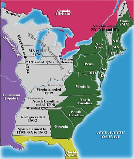
The state cessions are those areas of the then-"western" United States that the separate states ceded to the federal goverment in the 1780s (more or less) by the new 13 states of that union—in some cases in exchange for federal assumption of the colonies' American Revolutionary War debts.

Not all states (seven of the 13) had western land claims, so the state cessions were also key to getting the "landless" states to sign the U.S. Constitution--they had been fearful that a Virginia which reached to the Mississippi would quickly ovewhelm the states which were limited to their land overlooking the Atlantic Ocean.
Most of the western land claims were ceded between 1781 and 1787, with only Georgia holding out until the 19th century. The cessions were not entirely selfless, but the states' reasonably graceful cessions of their often-conflicting claims between their current extents and the Mississippi River prevented early, perhaps catastrophic, rifts among the states of the young Republic and allowed the settlement of the Upper Midwest and the expansion of the U.S. into the center of the North American continent.
The state cessions comprise 236,825,600 acres (958,399 km2), or 10.4 percent of current United States territory.
Landed states
- Date ceded: 1781
- Claims, cessions and dispute resolutions: Ceded claims west of Lake Ontario, sold Erie Triangle to Pennsylvania, stopped squabbling over what would become Vermont.
- Date ceded: 1784
- Claims and cessions: Ceded its territory north and west of the Ohio River (and east of the Mississippi), the land which was to be come the Northwest Territory. The land south and east of the Ohio was not ceded and was then called Kentucky County, Virginia. It was organized and admitted as Kentucky in short order (1792).
- Year ceded: 1784
- Year accepted by Congress: 1790
- Claims and cessions: Ceded what became the Southwest Territory, quickly transformed and admitted as Tennessee (1796).
- Date ceded: 1786
- Claims and cessions: Ceded swath between present north and south border-latitudes across present-day Michigan and Wisconsin, to which it was entitled by its interpretation of its original sea-to-sea grant from the British crown.
- Dates ceded: 1787
- Claims and cessions: Ceded land from western border to Mississippi River, but held back Connecticut Western Reserve in Ohio Country.
- Date ceded: 1787
- Claims and cessions: Claimed narrow 12-mile strip from western tip to Mississippi, running above Georgia and what would later become Mississippi and Alabama. Surrendered land to Georgia and U.S. gov't. However, the claim was for land between the headwaters of the Savannah River and the North Carolina boundary, but since the Savannah headwaters actually began in North Carolina, "the strip did not exist in reality."
- Date ceded: April 26, 1802, 15 years after all other cessions made
- Claims: Yazoo lands, between 31 to 35 degrees north latitude to Mississippi River
- Cost to U.S. government, unique among the "cessions": $1.25 million
Landless states

Note: These states may have had western (or other) land claims during their colonial eras, but by the 1780s, were generally out of the expansion business.
- Pennsylvania: Original grant land between 39th and 42nd north latitude for 5 degrees; had claims to Erie Triangle, which was ceded 1781-1785 to the federal government by New York and Massachusetts. The U.S. government, in turn, sold it back to Pennsylvania in 1788.
- New Hampshire: Claimed New Hampshire Grants/Vermont, but had no legal standing.
- Rhode Island
- Delaware
- Maryland
- New Jersey