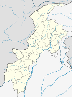
Azam Warsak
Appearance
This article, Azam Warsak, has recently been created via the Articles for creation process. Please check to see if the reviewer has accidentally left this template after accepting the draft and take appropriate action as necessary.
Reviewer tools: Inform author |
Azam Warsak
اعظم ورسک | |
|---|---|
 Dramatic scenery of Azam Warsak | |
| Coordinates: 32°17′15.8″N 69°24′49.5″E / 32.287722°N 69.413750°E | |
| Country | |
| Province | |
| District | South Waziristan |
| Tehsil | Birmal Tehsil |
| Elevation | 1,387 m (4,551 ft) |
| Time zone | UTC+5 (PST) |
| [1] | |
Azam Warsak is a village located in Birmal Tehsil, which is located west of Wana.[2] It is located approximately 20 kilometers from the city of Wana.[3]
See also
References
- ^ "Map of Azam Warsak in Federally Administered Tribal Areas, Pakistan". Archived from the original on 10 October 2020. Retrieved 9 October 2020.
- ^ "NA-50 South Waziristan Agency Area, Map, Candidates and Result". Political, Sports Workers Helpline. Archived from the original on 7 October 2020. Retrieved 7 October 2020.
- ^ "How far is Azam Warsak from Wana". Distance Calculator. Archived from the original on 9 October 2020. Retrieved 9 October 2020.
This article, Azam Warsak, has recently been created via the Articles for creation process. Please check to see if the reviewer has accidentally left this template after accepting the draft and take appropriate action as necessary.
Reviewer tools: Inform author |


