
2005 Pacific typhoon season
This article documents a current event. Information may change rapidly and initial news reports may be unreliable. The latest updates to this article may not reflect the most current information. |
The 2005 Pacific typhoon season has no official bounds; it runs year-round in 2005, but most tropical cyclones tend to form in the northwestern Pacific Ocean between June and December. These dates conventionally delimit the period of each year when most tropical cyclones form in the northwestern Pacific Ocean.
The scope of this article is limited to the Pacific Ocean, north of the equator and west of the international date line. Storms that form east of the date line and north of the equator are called hurricanes; see 2005 Pacific hurricane season. Tropical Storms formed in the entire west pacific basin are assigned a name by the Tokyo Typhoon Center. Tropical depressions in this basin have the "W" suffix added to their number. Tropical depressions that enter or form in the Phillipine area of responsibility are assigned a name by the Philippine Atmospheric, Geophysical and Astronomical Services Administration or PAGASA. This can often result in the same storm having two names.
Storms
Tropical Storm Kulap
- University of Hawaii's tracking chart of Tropical Storm Kulap.
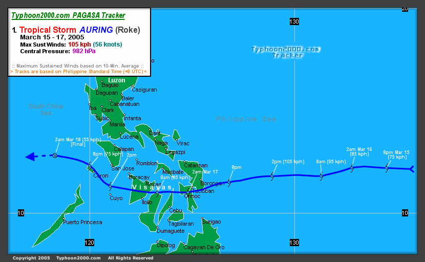
Typhoon Roke (Auring)
- Typhoon 2000's tracking chart of Typhoon Roke (Auring).
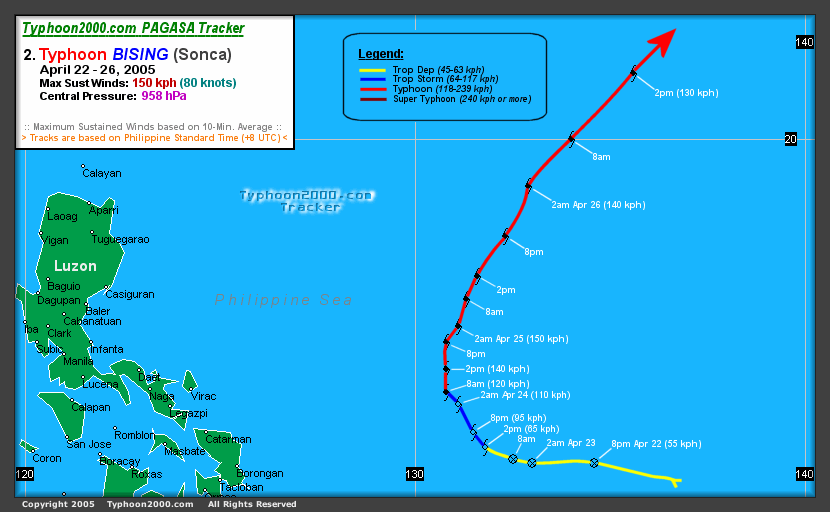
Typhoon Sonca (Bising)
- Typhoon 2000's tracking chart of Typhoon Sonca (Bising).
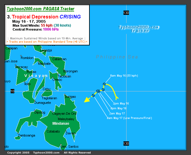
Tropical Depression 96W (Crising)
A short lived Tropical Depression formed near the Phillipines on May 16th at 0000 UTC (0800 PHT) 180 nautical miles east of Surigao on Mindanao Island. It was assigned the name Crising by PAGASA. The storm never organized into a Tropical Storm and did not receive the more recognized International name for west pacific storms. The storm drifted northwest then southwest and and began losing convection. PAGASA stopped tracking the storm 24 hours later on the 17th at 0000 UTC (0800 PHT) 145 nautical miles east of Surigao.
- Typhoon 2000's tracking chart of Tropical Depression (Crising).
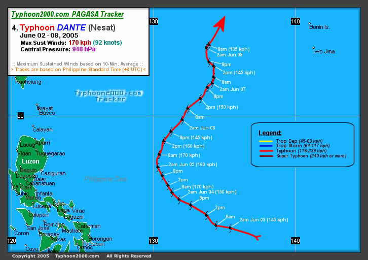
Typhoon Nesat (Dante)
- Typhoon 2000's tracking chart of Typhoon Nesat (Dante).
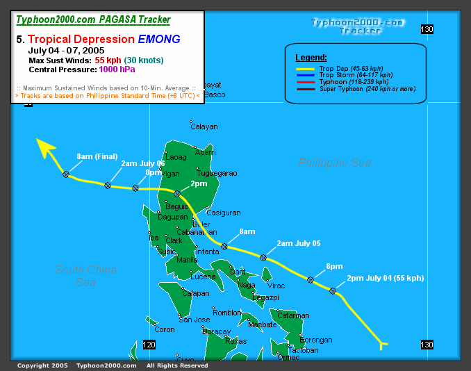
Tropical Depression 93W (Emong)
A Tropical Depression formed near the Phillipines on July 4th at 0600 UTC (1400 PHT) 35 nautical miles northeast of Catarman on Samar Island. It was assigned the name Emong by PAGASA. The storm never organized into a Tropical Storm and did not receive the more recognized International name for west pacific storms. As a poorly organized depression it drifted over Luzon on the 5th. Landfall and upper level shear caused the storm to lose organization on the 6th as it was 40 nautical miles south of Hong Kong.
- Typhoon 2000's tracking chart of Tropical Depression (Emong).
Super Typhoon Haitang (Feria)
- Main article: Typhoon Haitang
Super Typhoon Haitang (Feria) was the first major Typhoon of the 2005 season in the north west Pacific. It formed on the evening of July 11th as a poorly organized depression 110 nautical miles west of Marcus Island Japan at 1200 UTC (2000 JST). At the 1800 UTC (0300 JST July 13th) update it had reached Tropical Storm strength and was named Haitang, a Chinese name for flowering crabapple. It grew to Typhoon strength on the 13th at 1800 UTC the following day (0300 JST July 14th). As it moved westward it continued to gain in strength reaching category 3 as it entered the Phillipine area of responsibility. PAGASA named the storm Feria for Phillipine warnings on July 15th. By the 16th the storm continued tracking west and became a threat to Taiwan and Japan's Sakishima Islands as it strengthened to a category 5 Super Typhoon. On the 17th it weakened to a category 3 as it continued west sparing Sakishima a direct hit but aiming directly for Taiwan. Typhoon Haitang made landfall near Hualien Taiwan at 0000 UTC (0800 HKT) on the morning of July 18th. Taking a full day to cross the island and over the interior mountains it caused flash floods and landslides killing 4. Weakened to a tropical storm as it entered the South China Sea it reorganized into a minimal typhoon as it approached the south east China coast. Haitang made landfall for the second time near Wenzhou China on the 19th at 1200 UTC (2000 HKT). Moving inland it rapidly lost its strength. PAGASA stopped issuing advisiores for the storm near Jiangxi on the 20th.
- University of Hawaii's tracking chart of Super Typhoon Haitang (Feria).
Tropical Storm Nalgae
Tropical Storm Nalgae formed from a tropical disturbance 325 nautical miles northwest of Wake Island on the morning of July 20th. Nalgae is a Korean word for flying or dynamic motion. Nalgae did not reach typhoon intensity or threaten land. It turned to the north and then east, avoiding Japan.
- University of Hawaii's tracking chart of Tropical Storm Nalgae.
Tropical Storm Banyan
Tropical Storm Banyan formed from a tropical disturbance 300 nautical miles north of Yap Island on the evening of July 21st at 1200 UTC (2100 JST). Banyan is a Chinese word for a tree common in southern China. Banyan brushed the south and eastern coasts of Honshu Island Japan on July 26th. It became extratropical off the northeast coast of Honshu on July 27th.
- University of Hawaii's tracking chart of Tropical Storm Banyan.
Tropical Storm Washi
Tropical Storm Washi formed as a depression 215 nautical miles south of Hong Kong. Washi is a Japanese word for the constellation Aquila the Eagle. The storm moved west towards Hainan Island. Tropical Storm Washi made it's first landfall near Xinglong Hainan island China. After reentering the Gulf of Tonkin, the storm made it's final landfall near Nam Dinh, Vietnam.
- University of Hawaii's tracking chart of Tropical Storm Washi.
Typhoon Matsa (Gorio)
Typhoon Matsa (Gorio) formed as a depression 130 nautical miles west northwest of Yap Island. Matsa is a Laotian name for a lady fish. Matsa formed east of and then moved into the Phillipine area of responsibility. It has been assigned the name Gorio for Phillipine advisories. Matsa is expected to continue moving to the northwest passing between Taiwan and Okinawa on the morning of August 5th. On the current projected path, the Yaeyama Islands of Japan would take a direct hit from the storm.
Current
As of 0600 UTC on August 3, the center of Typhoon Matsa (Gorio) is 305 nautical miles south-southwest of Okinawa, Japan, and moving northwest at 8 knots with maximum sustained winds of 75 knots.
- Joint Typhoon Warning Center's tracking chart of Typhoon Matsa (Gorio).
Timeline of events
July
- July 11
- July 13
- 1800 UTC - Tropical Storm Haitang upgraded to Typhoon Haitang.
- July 14
- 1200 UTC - Typhoon Haitang intensifies to a Category 2 storm.
- July 15
- July 16
- 0000 UTC - Typhoon Haitang (Feria) upgraded to category 5 Super Typhoon with 130 knot winds.
- July 17
- 0600 UTC - Super Typhoon Haitang (Feria) downgraded to category 4 Typhoon with 125 knot winds.
- July 18
- July 19
- July 20
- 0000 UTC - Tropical depression 06W forms at 24.1N 163.8E sustained winds 30 knots, moving northwest at 6 knots.
- 0600 UTC - Tropical depression 06W upgraded to Tropical Storm Nalgae. Tropical Depression Haitang (Feria) is inland near Jiangxi China. Windspeed is down to 25 knots. PAGASA stopped issuing advisories at this time.
- July 21
- 1200 UTC - Tropical Depression 07W 300 nautical miles north of Yap Island in the Federated States of Micronesia.
- 1800 UTC - Tropical Depression 07W upgraded to Tropical Storm Banyan.
- July 23
- 1200 UTC - Tropical Storm Nalgae downgraded to a tropical depression, no further advisiories will be issued.
- July 26
- Tropical Storm Banyan brushes the south and east coasts of Honshu Island Japan
- July 27
- July 28
- July 29
- 1200 UTC - Tropical Depression 08W upgraded to Tropical Storm Washi.
- July 30
- 0000 UTC - Tropical Storm Washi makes landfall on Hainan Island, China.
- July 31
- 0000 UTC - Tropical Depression 09W forms 130 nautical miles west northwest of Yap Island.
- 0500 UTC - Tropical Storm Washi makes landfall near Nam Dinh, Vietnam.
- 0600 UTC - Tropical Depression 09W upgraded to Tropical Storm Matsa (Gorio).
- 1800 UTC - Tropical Depression Washi dissipates over northern Vietnam.
August
2005 storm names
Western North Pacific tropical cyclones are named by the Tokyo Typhoon Centre of the Japan Meteorological Agency. Names are selected from the following lists, and were contributed by members of the WMO Typhoon Committee. Each of 14 nations or territories submitted 10 names, which are used in alphabetical order by the English name of the country. Names that have not yet been assigned are marked in gray. Bold names are currently active.
| Contributing Nation | Names | ||||
|---|---|---|---|---|---|
| Cambodia | Damrey | Kong-rey | Nakri | Krovanh | Sarika |
| China | Longwang | Yutu | Fengshen | Dujuan | Haima |
| DPR Korea | Kirogi | Toraji | Kalmaegi | Maemi | Meari |
| Hong Kong | Kai-Tak | Man-yi | Fung-wong | Choi-wan | Ma-on |
| Japan | Tenbin | Usagi | Kammuri | Koppu | Tokage |
| Laos | Bolaven | Pabuk | Phanfone | Ketsana | Nock-ten |
| Macau | Chanchu | Wutip | Vongfong | Parma | Muifa |
| Malaysia | Jelawat | Sepat | Rusa | Melor | Merbok |
| Micronesia | Ewinlar | Fitow | Sinlaku | Nepartak | Nanmadol |
| Philippines | Bilis | Danas | Hagupit | Lupit | Talas |
| RO Korea | Gaemi | Nari | Changmi | Sudal | Noru |
| Thailand | Prapiroon | Vipa | Mekkhala | Nida | Kulap |
| U.S.A. | Maria | Francisco | Higos | Omais | Roke |
| Vietnam | Saomai | Lekima | Bavi | Conson | Sonca |
| Cambodia | Bopha | Krosa | Maysak | Chanthu | Nesat |
| China | Wukong | Haiyan | Haishen | Dianmu | Haitang |
| DPR Korea | Sonamu | Podul | Pongsona | Mindule | Nalgae |
| Hong Kong | Shanshan | Lingling | Yanyan | Tingting | Banyan |
| Japan | Yagi | Kajiki | Kujira | Kompasu | Washi |
| Laos | Xangsane | Faxai | Chan-hom | Namtheun | Matsa (active) |
| Macau | Bebinca | Vamei | Linfa | Malou | Sanvu (unused)
|
| Malaysia | Rumbia | Tapah | Nangka | Meranti | Mawar (unused)
|
| Micronesia | Soulik | Mitag | Soudelor | Rananin | Guchol (unused)
|
| Philippines | Cimaron | Hagibis | Imbudo | Malakas | Talim (unused)
|
| RO Korea | Chebi | Noguri | Koni | Megi | Nabi (unused)
|
| Thailand | Durian | Rammasun | Morakot | Chaba | Khanun (unused)
|
| U.S.A. | Utor | Chataan | Etau | Aere | Vicente (unused)
|
| Vietnam | Trami | Halong | Vamco | Songda | Saola (unused)
|
The Philippine Atmospheric, Geophysical and Astronomical Services Administration (PAGASA) uses its own naming scheme for tropical cyclones within its area of responsibility. Lists are recycled every four years. Names that have not yet been assigned are marked in gray. Bold names are currently active.
|
|
|
|
|
See also
- 2005 Pacific hurricane season
- 2005 Atlantic hurricane season
- 2005-06 Southern Hemisphere tropical cyclone season