
Louisiana
Louisiana (pronounced /luːˌiːziˈænə/ or /ˌluːziˈænə/) (French: Louisiane, pronounced GeographyTopographyThe state is bordered to the west by the state of Texas; to the north by Arkansas; to the east by the state of Mississippi; and to the south by the Gulf of Mexico. The surface of the state may properly be divided into two parts, the uplands, and the alluvial and coast and swamp regions. The alluvial regions, including the low swamps and coast lands, cover an area of about 20,000 square miles (52,000 km²); they lie principally along the Mississippi River, which traverses the state from north to south for a distance of about 600 miles (1,000 km) and ultimately emptying into the Gulf of Mexico, the Red River, the Ouachita River and its branches, and other minor streams. The breadth of the alluvial region along the Mississippi is from 10 to 60 miles (15 to 100 km), and along the other streams it averages about 10 miles (15 km). The Mississippi flows upon a ridge formed by its own deposits, from which the lands incline toward the low swamps beyond at an average fall of six feet per mile (3 m/km). The lands along other streams present very similar features. These alluvial lands are never inundated save when breaks occur in the levees by which they are protected against the floods of the Mississippi and its tributaries. These floods, however, do not occur annually, and they may be said to be exceptional. With the maintenance of strong levees these alluvial lands would enjoy perpetual immunity from inundation. The uplands and contiguous hill lands have an area of more than 25,000 square miles (65,000 km²), and they consist of prairie and woodlands. The elevations above sea-level range from 10 feet (3 m) at the coast and swamp lands to 50 and 60 feet (15-18 m) at the prairie and alluvial lands. In the uplands and hills the elevations rise to Driskill Mountain the highest point in the state at only 535 feet (163 m) above sea level. Only two other states in the union, Florida and Delaware, are geographically lower than Louisiana. However, Kansas, Oklahoma, Nebraska, Illinois, Indiana, Ohio, Wisconsin, and Michigan, though higher in elevation, have less topography. Besides the navigable rivers already named (some of which are called bayous), there are the Sabine, forming the western boundary, and the Pearl, the eastern boundary, the Calcasieu, the Mermentau, the Vermilion, the Teche, the Atchafalaya, the Boeuf, the Lafourche, the Courtableau, the D'Arbonne, the Macon, the Tensas, the Amite, the Tchefuncte, the Tickfaw, the Natalbany, and a number of other streams of lesser note, constituting a natural system of navigable waterways, aggregating over 4,000 miles in length, which is unequalled in the United States. The state also has 1,060 square miles (2,745 km²) of land-locked bays, 1,700 square miles (4,400 km²) of inland lakes, and a river surface of over 500 square miles (1,300 km²). GeologyThe underlying strata of the state are of Cretaceous age and are covered by alluvial deposits of Tertiary and post-Tertiary origin. A large part of Louisiana is the creation and product of the Mississippi River. It was originally covered by an arm of the sea, and has been built up by the silt carried down the valley by the great river. Near the coast, there are many salt domes, where salt is mined and oil is often found. Owing to the extensive flood control measures along the Mississippi river and to natural subsidence, Louisiana is now suffering the loss of coastal land area. State and federal government efforts to halt or reverse this phenomenon are under way; others are being sought. Protected areasLouisiana contains a number of areas which are, in varying degrees, protected from human intervention. In addition to several stations of the National Park Service, and a federally recognized National Forest, Louisiana itself operates, among other programs, a system of state parks and recreation areas throughout the state. National Park ServiceAreas under the management and protection of the National Park Service include:
National ForestKisatchie National Forest is Louisiana's only National Forest. Headquartered in Pineville, Kisatchie National Forest operates six separate districts in the north-central area of the state, for the most part between Shreveport, Monroe, and Alexandria. State Parks and Recreational AreasLouisiana operates a system of nineteen State Parks, sixteen State Historic Sites, and one State Preservation Area, which include all of the following: State Parks
State Historic Sites
State Preservation Area
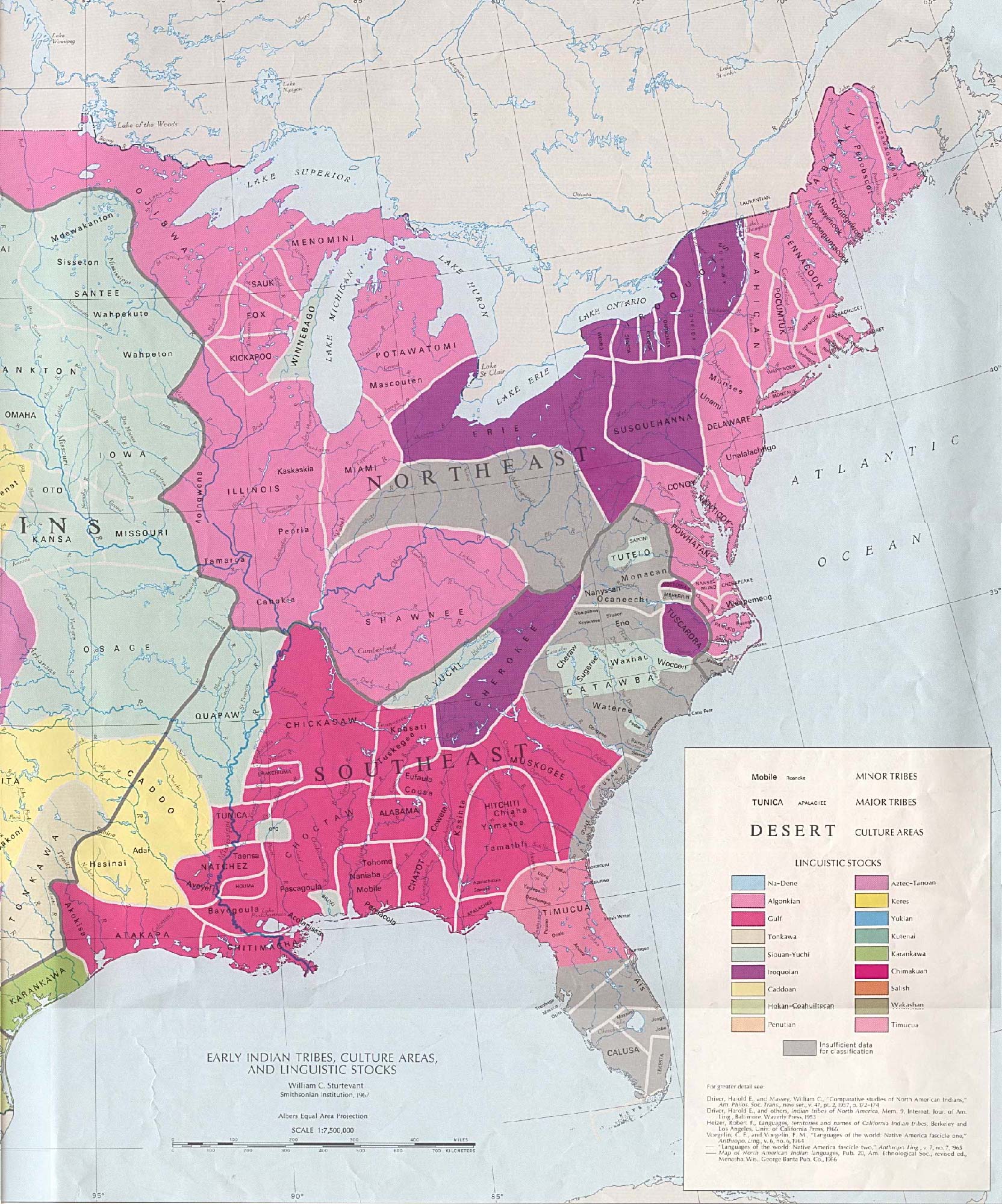
Louisiana Natural and Scenic RiversAdministered by the Louisiana Department of Wildlife and Fisheries, the Louisiana Natural and Scenic Rivers System provides a degree of protection for 48 rivers, streams, and bayous in the state. One of these, Saline Bayou, is also a National Wild and Scenic River. HistoryLouisiana was inhabited by Native Americans when European explorers arrived in the 17th century. Settlement and colonization began in the 18th century. Some current place names, including Atchafalaya, Natchitouches (now spelled Natchitoches), Caddo, Houma, Tangipahoa, and Avoyel (Avoyelles), are from Native American dialects. Several native tribes inhabited the region (using current parish boundaries to describe approximate locations):[1]
Exploration and settlementThe first European explorers to visit Louisiana came in 1528. The Spanish expedition (led by Panfilo de Narváez) located the mouth of the Mississippi River. In 1541, Hernando de Soto's expedition crossed the region. Then Spanish interest in Louisiana lay dormant. In the late 17th century, French expeditions, which included sovereign, religious and commercial aims, established a foothold on the Mississippi River and Gulf Coast. With its first settlements, France lay claim to a vast region of North America, and set out to establish a commercial empire and French nation stretching from the Gulf of Mexico to Canada. The French explorer Robert Cavelier de La Salle named the region Louisiana to honor France's King Louis XIV in 1682. The first permanent settlement, Fort Maurepas (at what is now Ocean Springs, Mississippi, near Biloxi), was founded by Pierre Le Moyne d'Iberville, a French military officer from Canada, in 1699. The French colony of Louisiana originally claimed all the land on both sides of the Mississippi River and north to French territory in Canada. The following States were part of Louisiana: Louisiana, Mississippi, Arkansas, Oklahoma, Missouri, Kansas, Nebraska, Iowa, Illinois, Indiana, Michigan, Wisconsin, Minnesota, North Dakota, South Dakota. The settlement of Natchitoches (along the Red River in present-day northwest Louisiana) was established in 1714 by Louis Juchereau de St. Denis, making it the oldest permanent settlement in the Louisiana Purchase territory. The French settlement had two purposes: to establish trade with the Spanish in Texas, and to deter Spanish advances into Louisiana. Also, the northern terminus of the Old San Antonio Road (sometimes called El Camino Real, or Kings Highway) was at Natchitoches. The settlement soon became a flourishing river port and crossroads, giving rise to vast cotton kingdoms along the river. Over time, planters developed large plantations and built fine homes in a growing town, a pattern repeated in New Orleans and other places. Louisiana's French settlements contributed to further exploration and outposts, concentrated along the banks of the Mississippi and its major tributaries, from Louisiana to as far north as the region called the Illinois Country, around Peoria, Illinois and present-day St. Louis, Missouri. See also: French colonization of the Americas Initially Mobile, Alabama and Biloxi, Mississippi functioned as the capital of the colony; recognizing the importance of the Mississippi River to trade and military interests, France made New Orleans the seat of civilian and military authority in 1722. From then until the Louisiana Purchase made the region part of the United States on December 20, 1803, France and Spain would trade control of the region's colonial empire. Most of the territory to the east of the Mississippi was lost to the Kingdom of Great Britain in the French and Indian War, except for the area around New Orleans and the parishes around Lake Pontchartrain. The rest of Louisiana became a colony of Spain after the Seven Years' War by the Treaty of Paris of 1763. During the period of Spanish rule, several thousand French-speaking refugees from the region of Acadia made their way to Louisiana following British expulsion; settling largely in the southwestern Louisiana, the Acadian refugees were welcomed by the Spanish, and descendants came to be called Cajuns. In 1800, France's Napoleon Bonaparte acquired Louisiana from Spain in the Treaty of San Ildefonso, an arrangement kept secret for some two years. Then in 1803, Bonaparte sold the territory to the United States, which (see Louisiana Purchase) divided it into two territories: the Orleans Territory (which became the state of Louisiana in 1812) and the District of Louisiana (which consisted of all the land not included in Orleans Territory). The Florida Parishes were annexed from Spanish West Florida by proclamation of President James Madison in 1810. The western boundary of Louisiana with Spanish Texas remained in dispute until the Adams-Onís Treaty in 1819, with the Sabine Free State serving as a neutral buffer zone as well as a haven for criminals. Louisiana was a slave state. It also had one of the largest free black populations in the United States.(see slavery) In the American Civil War, Louisiana seceded from the Union on January 26, 1861. New Orleans was captured by Federal troops on April 25, 1862. Because a large part of the population had Union sympathies (or compatible commercial interests), the Federal government took the unusual step of designating the areas of Louisiana under federal control as a state within the Union, with its own elected representatives to the U.S. Congress. Hurricane KatrinaOn August 29, 2005, Hurricane Katrina struck and devastated southeastern Louisiana, while damaged levees in New Orleans flooded the city. The city was essentially closed until October. Estimates are that more than two million people in the Gulf region were displaced by the hurricane, with more than a thousand storm fatalities in Louisiana. Public outcry criticized the government at the local, state, and federal levels, citing that response was neither fast nor adequate. The next month, southwestern Louisiana was struck by Hurricane Rita. Demographics
 As of July 2005 (pre-Katrina/Rita), Louisiana has an estimated population of 4,523,628, which is an increase of 16,943, or 0.4%, from the prior year and an increase of 54,670, or 1.2%, since the year 2000. This includes a natural increase since the last census of 129,889 people (that is 350,818 births minus 220,929 deaths) and a decrease due to net migration of 69,373 people out of the state. Immigration from outside the United States resulted in a net increase of 20,174 people, and migration within the country produced a net loss of 89,547 people. As of 2003, the state's population included approximately 215,000 native French-speakers. The racial makeup of the state is:
The five largest ancestries in the state are: African American and Franco-African (32.5%), French / French Canadian (16.2%), American (10.1%), German (7.1%), Irish (7%). Official Census statistics do not distinguish among people of African ancestry. Consequently, no distinction is made between those in Lousiana of English-speaking African-American heritage and those who consider themselves Franco-African or Creole, though their respective cultural identities may be quite different. Franco-Africans and African-American blacks, who made up a majority of the state's population during much of the 19th century, dominate much of the southeast, central, and northern parts of the state, particularly those parishes along the Mississippi River valley. But in recent years, the percentage of whites in those areas has grown, as large numbers of white senior citizens have begun to relocate there because of the friendly atmosphere, mild winters, and beautiful scenery. Creoles (of West African, French and/or Spanish ancestry) and Cajuns of French Canadian ancestry are dominant in much of the southern part of the state. Whites of Southern U.S. background predominate in northern Louisiana. LanguagesAs of 2000, 91.2% of Louisiana residents age 5 and older speak English at home and 4.8% speak French. Spanish is spoken by 2.5% of the population, Vietnamese is at 0.6% and German is at 0.2%. Among the states, Louisiana has a unique culture, owing to its French colonial heritage. While the state has no declared "official language," its law recognizes both English and French. The French language is mainly concentrated in the southernmost portion of the state, along the Gulf of Mexico, and the use of French is closely associated with Cajun ancestry [1]. ReligionLike the other Southern states, Louisiana is mostly Protestant; however, there is also a large native Catholic population in the state, particularly in the southern part of the state, which makes Louisiana unique among Southern states. The current religious affiliations of the people of Louisiana are shown in the table below:
The New Orleans area has a small but significant Jewish community. EconomyThe total gross state product in 2003 for Louisiana was US$140 billion. Its per capita personal income was US$26,312, forty-third in the United States. The state's principal agricultural outputs include seafood (It is the biggest producer of crawfish in the world), cotton, soybeans, cattle, sugarcane, poultry and eggs, dairy products, and rice. Its industrial outputs include chemical products, petroleum and coal products, food processing, transportation equipment, paper products, and tourism. Louisiana has 3 personal income tax brackets, ranging from 2 percent to 6 percent. The sales tax rate is 4 percent: a 3.97 percent Louisiana sales tax and a .03 percent Louisiana Tourism Promotion District sales tax. Political subdivisions also levy their own sales tax in addition to the state fees. The state also has a use tax, which includes 4 percent to be distributed by the Department of Revenue to local governments. Property taxes are assessed and collected at the local level. Transportation
There are proposed plans to extend Interstate 69 to Houston and on to the Texas/Mexico border, which will go through north-eastern Louisiana. Also, Interstate 49 is slated to be expanded north into Arkansas and east along Interstate 10 to New Orleans, replacing part of U.S. Highway 90. The city of Lake Charles has an east-west loop called Interstate 210, which provides interstate highway access across the city.
Law and government In 1849 the state moved the capital from New Orleans to Baton Rouge. Donaldsonville, Opelousas, and Shreveport have briefly served as the seat of Louisiana state government. The current Louisiana governor is Kathleen Babineaux Blanco (Democrat), and its two U.S. senators are Mary Landrieu (Democrat) and David Vitter (Republican). Louisiana has seven Members of Congress: five Republicans and two Democrats. From its time as a possession of France, Louisiana retains a civil law legal system, based on the Louisiana Civil Code, which is similar to (and often confused with) the Napoleonic Code (like France, and unlike the rest of the United States, which uses a common law legal system derived from England). Also derived from French governance is the use of the term "parishes" in place of "counties" for the subdivisions of government. Louisiana is the only state whose legal system is based on Roman, Spanish, and French civil law as opposed to English common law. Technically, it is known as "Civil Law," or the "Civilian System." It is often incorrectly referred to as the "Code Napoléon" or The Napoleonic Code. The state is officially governed by the Louisiana Civil Code of 1870, and has never officially governed by the Napoleonic Code. While the Napoleonic Code certainly influenced the state's code, the Napoleonic Code's formal enactment in 1804 happened after the Louisiana Purchase in 1803. While the state's 1870 code has been continuously revised and updated since its enactment, it is still considered the controlling authority in the state. The civilian system is by and large the most widely practiced system of law in the world, as it is the system of law in much of continental Europe, Quebec (Canada), Japan, Latin America, and most former colonies of continental European countries. Great differences still exist between Louisiana Civil Law and the Common Law found in her 49 sister states. While some of these differences have been bridged due to the strong influence of the Common Law in the United States,[2] it is important to note that the "Civilian" tradition is still deeply rooted in most aspects of Louisiana private law. Thus property, contractual, business entities structure, much of civil procedure, and family law are still mostly based on traditional Roman legal thinking. In contrast, criminal law is entirely based on the Anglo-American Common Law. Louisiana is unique among U.S. states in its method for state, local, and congressional elections. All candidates, regardless of party affiliation, run in an open primary on Election Day. If no candidate has more than 50% of the vote, the two candidates with the highest vote total compete in a runoff election approximately one month later. This runoff does not take into account party identification; therefore, it is not uncommon for a Democrat to be in a runoff with a fellow Democrat or a Republican to be in a runoff with a fellow Republican. All other states use single-party primaries followed by a general election between party candidates, each conducted by either a plurality voting system or runoff voting, to elect Senators, Representatives, and statewide officials. Louisiana has a statewide police force, the Louisiana State Police. It began in 1922 and its motto is "courtesy, loyalty, service." Its troopers have statewide jurisdiction with power to enforce all laws of the state, including city and parish ordinances. Each year, they patrol over 12 million miles (20 million km) of roadway and arrest about 10,000 impaired drivers. Troopers are also responsible for investigating the casino and gaming industry, all hazardous material incidents, anti-terrorism training and general criminal, narcotics and insurance fraud investigations. Louisiana is the only state that calls its subdivisions parishes, rather than counties. Each parish in Louisiana has an elected sheriff, with the exception of Orleans Parish. It has two elected sheriffs - one criminal and one civil. The sheriffs are responsible for general law enforcement in their respective parish. Orleans Parish is an another exception to this rule as the general law enforcement duties fall to the New Orleans Police Department. The sheriff also controls and manages the parish jail and/or correctional facility. The sheriff is also the tax collector for each parish. Most parishes are governed by a Police Jury. Eighteen of the sixty-four parishes are governed under an alternative form of government under a Home Rule Charter. They oversee the parish budget and operate the parish maintenance services. This includes parish road maintenance and other rural services. See also LA Sheriff's Association,LA Parish Government Largest cities and towns
| |||||||||||||||||||||||||||||||||||||||||||||||||||||||||||||||||||||||||||||||||||||||||||||||||||||||||||||||||||||||||||||||||||||||||||||||||||||||||||||||||||||||||||||||||||||||||||||||||||||||||||||||||||||||||||||||||||||||||||||||||||||||||||||||

