
User talk:Ahoerstemeier/Archive 1
Hello and Welcome! I hope you like the place. --mav
Hello, I've seen your new articles about Maerkischer Kreis and Hemer, Germany. I don't know if you plan to add more articles on German towns and districts; if so, that would be great, since your contributions are really good, and my progress in adding this stuff is quite slow. Just a little remark: We don't have to name articles Hemer, Germany, if just one Hemer exists on this planet (or is likely to be the only one mentioned in an article). So the title of the article should be just Hemer (and accordingly for the other towns added in List of cities in Germany). Have fun -- Cordyph 21:56 Feb 11, 2003 (UTC)
Hi again, I would like to adopt your idea of stating the names of all towns and municipalities in the district articles. Do you know an internet source, where it is possible to find out, if a place is a town/city or just a municipality, i.e. if it has "city rights"? I just have a written source, which may be somewhat outdated in some cases. (Of course it is possible to find this out on the town's websites themselves, but that is a little bit arduous.) -- Cordyph 20:30 Feb 19, 2003 (UTC)
- I usually find them on the webpages of the district itself, in most cases those give all the information I put in the articles. Only rarely I have to check the website of the city/muncipality itself to see how they call themself. Also a source is [1] -- andy 21:18 Feb 19, 2003 (UTC)
- Okay, that's what I used to do as well - some district pages do not contain this information, but never mind, somehow we will find the information. I keep off the NRW districts for a short while in order to set up the pages for the other Bundesländer and, maybe, to enlarge the list of cities according to the aim of including every town having "city rights".
I am thinking about setting up a new WikiProject, similar to the Swedish Counties Project. In a WikiProject German districts we could define a template, which includes more details than the current district pages. That does not mean, that we shall begin our entire work anew. My thoughts are unsorted yet, but a district template should include a table with the basic facts, maybe the district's coat of arms and a full list of towns and municipalities. What do you think? If you are interested as well, I would like to set up a WikiProject page, where we can discuss about the template. -- Cordyph 07:16 Feb 20, 2003 (UTC)
- Okay, that's what I used to do as well - some district pages do not contain this information, but never mind, somehow we will find the information. I keep off the NRW districts for a short while in order to set up the pages for the other Bundesländer and, maybe, to enlarge the list of cities according to the aim of including every town having "city rights".
- I will join such a project for sure, even though I most like to spend my energy on the districts and cities near my former and my present hometown :-) I already started by applying the template you used for the states like North Rhine-Westphalia to Maerkischer Kreis. I just added the car license, removed the stuff in the table from the text, put the towns into a list, added the neighboring districts and added some sections into the text. I think only the map can use some improvement now, due to the fact I started with your JPEG version and tried to clean it for PNG it's still not as sharp as it could be. Or did I left out anything you had in mind? -- andy 22:49 Feb 23, 2003 (UTC)
- Hello, that looks absolutely great!! I am too tired now, but tomorrow I will set up the WikiProject according to your template. (Of course you may do it as well, if you want.) I will try to find other participants. Today and yesterday I expanded the remaining Bundesland articles, only Baden-Württemberg and Saarland are not included in List of German districts yet. Maybe, I will conclude that tomorrow as well, and then we have nothing else to do than adding those 431 district articles - wait, it's only 430 articles left ;-) BTW, the state template was created by JeLuF, not by me. As for the maps, I will create some PNG templates, that we can use instead of the JPEGs, and place them on my user page. -- Cordyph 23:13 Feb 23, 2003 (UTC)
I just defined the WikiProject. Please have a look. It meets your template, but I added two rows in the factsheet and one more section at the bottom. For discussing the template and other stuff related to the project, we should use the WikiProject's talk page from now on. -- Cordyph 11:15 Feb 24, 2003 (UTC)
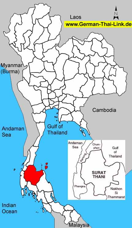
Hi! Great maps for the Thai provinces and German Bundeslaender. Would anything similiar be available for China and/or France? Thanks. olivier 02:59 Mar 8, 2003 (UTC)
- The german maps were created by Cordyph, who created templates for all federal states - I don't know how he created them however. The Thai map I used for Surat Thani province I edited from a map I found in web, and modified it until it was same style as the ones for germany. If I find a good starting map for other countries I can do the same with them for sure. Another way to create such a map is the PanMap software, a free simple GIS tool, and it has the vector data for provincial borders there as well. Sadly the one for France does not use the departement borders, but the province border, but for China it seems to be the right borders. -- andy 15:19 Mar 8, 2003 (UTC)
- I have replied to your comment on my talk page. Thanks! olivier 09:44 Mar 15, 2003 (UTC)
- Thanks. I have replied again. olivier 01:17 Mar 17, 2003 (UTC)
- and again. olivier 13:11 Mar 19, 2003 (UTC)
Of course I don't mind, if you add the maps. I didn't in the last time, because on the weekends I work on a different computer (without a graphics tool). I would have added those maps this week, but if you do it, that is okay as well. -- Cordyph 16:00 Mar 10, 2003 (UTC)
Thanks for the maps. I was really surprised to find them already there :-) -- Cordyph 23:41 Mar 23, 2003 (UTC)