Saint-Jouvent: Difference between revisions
Content deleted Content added
m rm unused infobox parameters |
Tournasol7 (talk | contribs) No edit summary |
||
| Line 2: | Line 2: | ||
|name = Saint-Jouvent |
|name = Saint-Jouvent |
||
|commune status = [[Communes of France|Commune]] |
|commune status = [[Communes of France|Commune]] |
||
|image = Town hall of Saint-Jouvent (3).jpg |
|||
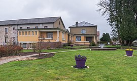
|caption = Town hall of Saint-Jouvent |
|||
|coordinates = {{coord|45.9578|1.2056|format=dms|display=inline,title}} |
|coordinates = {{coord|45.9578|1.2056|format=dms|display=inline,title}} |
||
|INSEE = 87152 |
|INSEE = 87152 |
||
Revision as of 12:45, 19 April 2021
Saint-Jouvent | |
|---|---|
 Town hall of Saint-Jouvent | |
| Coordinates: 45°57′28″N 1°12′20″E / 45.9578°N 1.2056°E | |
| Country | France |
| Region | Nouvelle-Aquitaine |
| Department | Haute-Vienne |
| Arrondissement | Limoges |
| Canton | Couzeix |
| Government | |
| • Mayor (2008–2014) | Jean-Jacques Faucher |
| Area 1 | 24.96 km2 (9.64 sq mi) |
| Population (2021)[1] | 1,659 |
| • Density | 66/km2 (170/sq mi) |
| Time zone | UTC+01:00 (CET) |
| • Summer (DST) | UTC+02:00 (CEST) |
| INSEE/Postal code | 87152 /87510 |
| Elevation | 305–437 m (1,001–1,434 ft) |
| 1 French Land Register data, which excludes lakes, ponds, glaciers > 1 km2 (0.386 sq mi or 247 acres) and river estuaries. | |
Saint-Jouvent (Occitan: Sent Jauvenç) is a commune in the Haute-Vienne department in the Nouvelle-Aquitaine region in west-central France.
See also
References
- ^ "Populations légales 2021". The National Institute of Statistics and Economic Studies. 28 December 2023.
Wikimedia Commons has media related to Saint-Jouvent.


