
2005 Pacific typhoon season
This article documents a current event. Information may change rapidly and initial news reports may be unreliable. The latest updates to this article may not reflect the most current information. |
The 2005 Pacific typhoon season has no official bounds; it runs year-round in 2005, but most tropical cyclones tend to form in the northwestern Pacific Ocean between June and December. These dates conventionally delimit the period of each year when most tropical cyclones form in the northwestern Pacific Ocean.
The scope of this article is limited to the Pacific Ocean, north of the equator and west of the international date line. Storms that form east of the date line and north of the equator are called hurricanes; see 2005 Pacific hurricane season. Tropical storms that form in the West Pacific basin are assigned a name by the Tokyo Typhoon Center. Tropical depressions in this basin have the "W" suffix added to their number. Tropical depressions that enter or form in the Philippine area of responsibility are assigned a name by the Philippine Atmospheric, Geophysical and Astronomical Services Administration or PAGASA. This can often result in the same storm having two names.
This season, the circular list of 140 names, in use since January 1, 2000, was recycled following the formation of Typhoons Saola; the final name on the list, and Damrey; the first name on the list.
| Saffir-Simpson Typhoon Scale | ||||
|---|---|---|---|---|
| Category | Wind speed | |||
| Knots (km/h) | ||||
| Category 5 | > 136 (250) | |||
| Super Typhoon | > 130 (240) | |||
| Category 4 | 114–135 | |||
| (210–249) | ||||
| Category 3 | 97–113 | |||
| (178–209) | ||||
| Category 2 | 83–96 | |||
| (154–177) | ||||
| Typhoon Category 1 | 64–82 | |||
| (119–153) | ||||
| Tropical Storm | 30–63 | |||
| (56–118) | ||||
Storms
Please note that on the following list, storms are listed by Tropical Depression number, and therefore Saola (18W), which is on the naming list before Damrey (17W), is listed after Damrey, having been the later storm to form, despite being the earlier to attain Tropical Storm status.
Tropical Storm Kulap
- University of Hawaii's tracking chart of Tropical Storm Kulap.
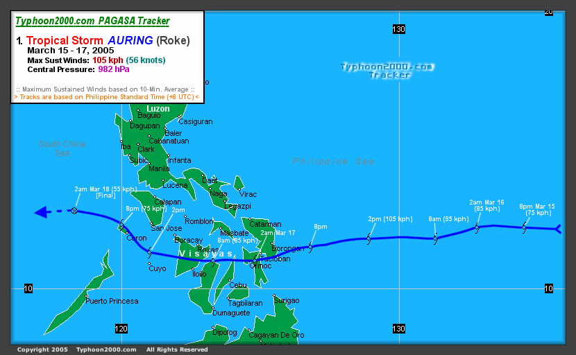
Typhoon Roke (Auring)
- Typhoon 2000's tracking chart of Typhoon Roke (Auring).
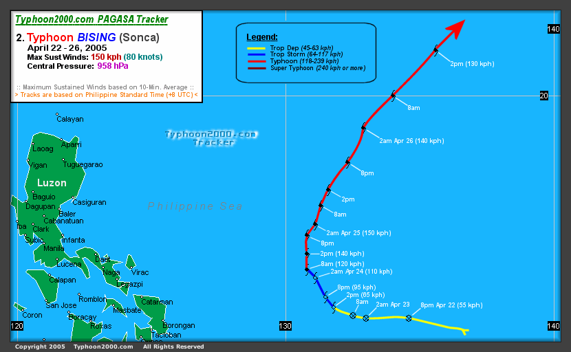
Typhoon Sonca (Bising)
- Typhoon 2000's tracking chart of Typhoon Sonca (Bising).
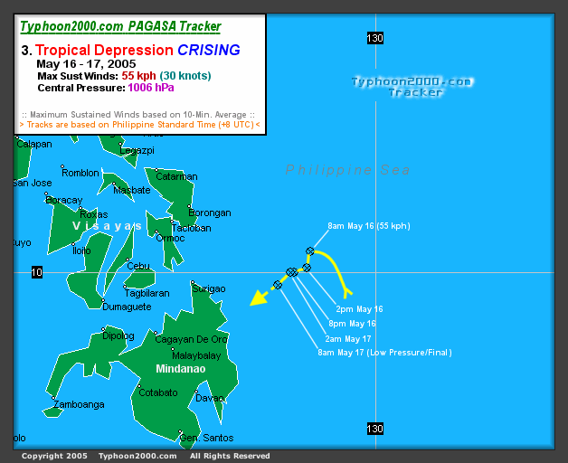
Tropical Depression 96W (Crising)
A short lived tropical depression formed near the Philippines on May 16 at 0000 UTC (0800 PHT) 180 nautical miles (330 km) east of Surigao on Mindanao Island. It was assigned the name Crising by PAGASA. The storm never organized into a tropical storm and did not receive the more recognized International name for West Pacific storms. The storm drifted northwest then southwest and began losing convection. PAGASA stopped tracking the storm 24 hours later on the 17th at 0000 UTC (0800 PHT) 145 nautical miles (270 km) east of Surigao.
- Typhoon 2000's tracking chart of Tropical Depression 96W(Crising).
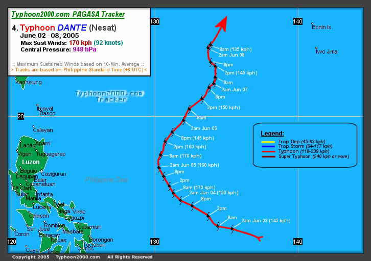
Typhoon Nesat (Dante)
Typhoon Nesat (Dante) was a powerful storm that formed on May 30 about 290 nautical miles (540 km) south-southeast of Guam as Tropical Depression 04W. It was quickly upgraded to Tropical Storm Nesat overnight at 1800 UTC (0200 PHT May 31). Nesat is a Cambodian word for fishing. On the evening of June 1, it strengthened into Typhoon Nesat. On June 2, it entered the Philippine area of responsibility and was assigned the name Dante for Philippine warnings. Typhoon Nesat (Dante) quickly grew to a category 4 storm as it approached the Philippines, but it curved away to the northeast and did not pose a threat to land. Waxing and waning in strength it eventually became extratropical southeast of Honshu, Japan at tropical storm strength on the morning of June 10 at 0000 UTC (0900 JST).
- Typhoon 2000's tracking chart of Typhoon Nesat (Dante).
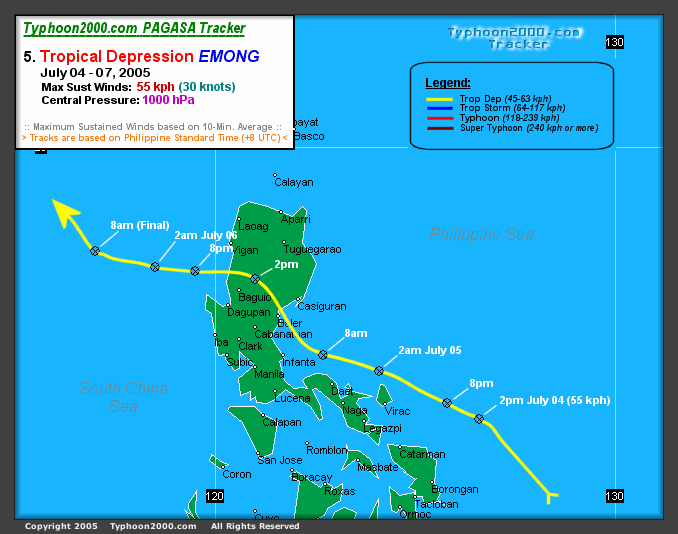
Tropical Depression 93W (Emong)
A tropical depression formed near the Philippines on July 4 at 0600 UTC (1400 PHT) about 35 nautical miles (65 km) northeast of Catarman on Samar Island. It was assigned the name Emong by PAGASA. The storm never organized into a tropical storm and did not receive the more recognized International name for West Pacific storms. As a poorly organized depression it drifted over Luzon on July 5. Upper-level shear and the depression's landfall caused the storm to lose organization on July 6 while located about 40 nautical miles (75 km) south of Hong Kong.
- Typhoon 2000's tracking chart of Tropical Depression 93W(Emong).
Super Typhoon Haitang (Feria)

Super Typhoon Haitang (Feria) was the first major typhoon of the 2005 season in the northwestern Pacific. It formed on the evening of July 11 as a poorly organized depression about 110 nautical miles (280 km) west of Marcus Island, Japan at 1200 UTC (2000 JST). By 1800 UTC (0300 JST July 13), it had reached tropical storm strength and was named Haitang, a Chinese name for flowering crabapple. It grew to typhoon strength at 1800 UTC (0300 JST July 14) the following day. As it moved westward it continued to gain in strength, reaching category three status as it entered the Philippine area of responsibility. PAGASA named the storm Feria for Philippine warnings on July 15. By July 16, the storm continued tracking west and became a threat to Taiwan and Japan's Sakishima Islands. Haitang strengthened into a category 5 super typhoon. On July 17 it weakened to a category 3 as it continued west, sparing Sakishima a direct hit but aiming directly for Taiwan. Typhoon Haitang made landfall near Hualien, Taiwan at 0000 UTC (0800 HKT) on the morning of July 18. Taking a full day to cross the island and over the interior mountains, it caused flash floods and landslides killing four people. Weakening to a tropical storm as it entered the South China Sea, it reorganized into a minimal typhoon as it approached the southeast China coast. Haitang made landfall for the second time near Wenzhou China on July 19 at 1200 UTC (2000 HKT). Moving inland, it rapidly lost its strength and dissipated. PAGASA stopped issuing advisories for the storm near Jiangxi on July 20.
- University of Hawaii's tracking chart of Super Typhoon Haitang (Feria).
Tropical Storm Nalgae
Tropical Storm Nalgae formed from a tropical disturbance 325 nautical miles (600 km) northwest of Wake Island on the morning of July 20. Nalgae is a Korean word for wing. Nalgae did not reach typhoon intensity or threaten land. It turned to the north and then east, avoiding Japan.
- University of Hawaii's tracking chart of Tropical Storm Nalgae.
Tropical Storm Banyan
Tropical Storm Banyan formed from a tropical disturbance about 300 nautical miles (550 km) north of Yap Island on the evening of July 21 at 1200 UTC (2100 JST). Banyan is a Chinese word for a tree common in southern China. Banyan brushed the southern and eastern coasts of Honshu, Japan on July 26. It became extratropical off the northeastern coast of Honshu on July 27.
- University of Hawaii's tracking chart of Tropical Storm Banyan.
Tropical Storm Washi
Tropical Storm Washi formed as a tropical depression about 215 nautical miles (400 km) south of Hong Kong. Washi is a Japanese word for the constellation Aquila. The storm moved west towards Hainan, China. Tropical Storm Washi made its first landfall near Xinglong, Hainan, China. After re-entering the Gulf of Tonkin, the storm made its final landfall near Nam Dinh, Vietnam.
- University of Hawaii's tracking chart of Tropical Storm Washi.
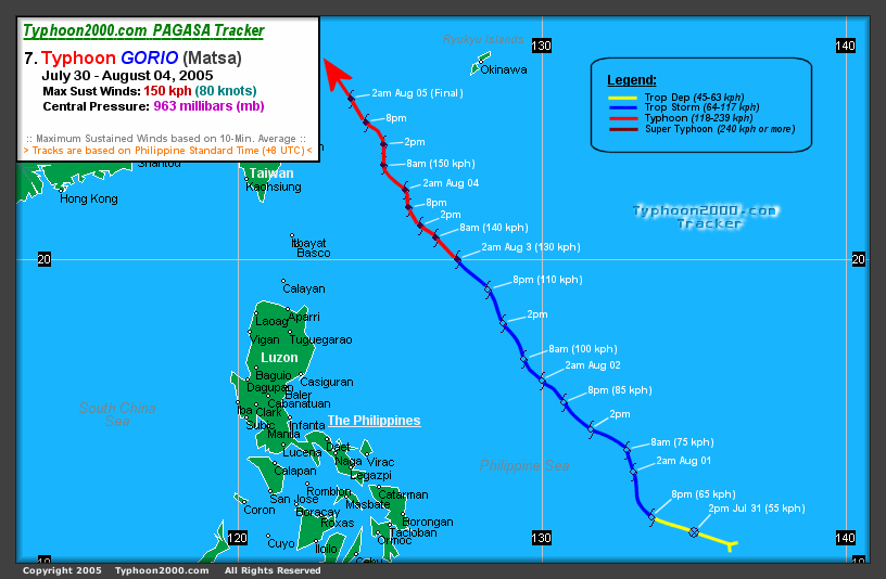
Typhoon Matsa (Gorio)
Typhoon Matsa (Gorio) formed as a depression 130 nautical miles (240 km) west northwest of Yap Island. Matsa is a Laotian name for a lady fish. Matsa formed east of and then moved into the Philippine area of responsibility. It has been assigned the name Gorio for Philippine advisories. Matsa passed between Taiwan and Okinawa with the center of the storm passing over the Yaeyama Islands of Japan on the evening of August 4. The storm made landfall near Zhejiang, Anhui, Jiangsu and Shanghai on mainland China on the morning of August 6 with maximum sustained winds of 145 km/h (90 mph). The storm rapidly dissipated inland over China but remnants brought heavy rain inland west of Shanghai.
- Typhoon 2000's tracking chart of Typhoon Matsa (Gorio).
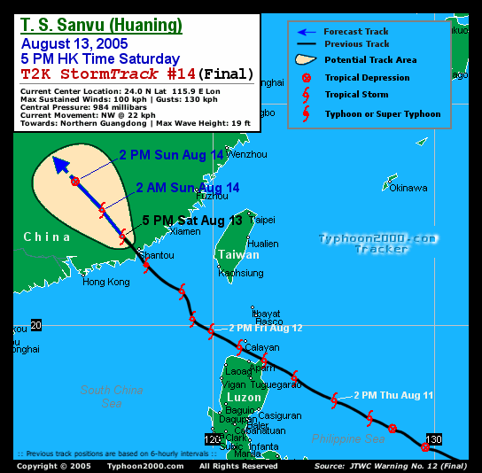
Typhoon Sanvu (Huaning)

Typhoon Sanvu (Huaning) formed as a tropical depression on the morning of August 10 at 0000 UTC (0800 PHT) 320 nautical miles east-northeast of Borongan on Samar Island inside the Philippine area of responsibility. PAGASA assigns names to Tropical Depressions because they often bring heavy rains and mudslides to the Philippines. Storm was named Tropical Depression Huaning for Philippine warnings but within 24 hours received the more recognized name Sanvu when it became a Tropical Storm. Sanvu is a Chinese name for coral. Tropical Storm Sanvu (Huaning) passed over a peninsula in Cagayan province on the island of Luzon early on the morning of August 12. It was upgraded to a typhoon before making landfall in China the next day on August 13. Sanvu (Huaning) rapidly dissipated after moving inland on August 14.
- Typhoon 2000's tracking chart of Typhoon Sanvu (Huaning).
Super Typhoon Mawar
Super Typhoon Mawar formed as a tropical depression on the evening of August 19 at 1200 UTC (2100 JST) 245 nautical miles (455 kilometers) southeast of Iwo Jima. Mawar is a Malaysian name for a rose. The storm intensified rapidly in two days to a category 4 Super Typhoon but weakened as it approached Japan. Mawar made landfall on Honshu as a category 2 Typhoon on August 25 at 1800 UTC (August 26 0300 JST) with winds of 95 mph (152 km/h). After moving inland to the northwest it was downgraded to a category 1 before entering the Pacific Ocean. It was downgraded to a Tropical Storm on August 26 and became extratropical on August 27. At least two people were killed by Mawar.
- University of Hawaii's tracking chart of Super Typhoon Mawar.
Tropical Storm Guchol
Tropical Storm Guchol formed as a tropical depression on the morning of August 20 at 0000 UTC (0900 JST) 190 nautical miles (350 kilometers) southwest of Marcus Island, Japan. It reached Tropical Storm strength the next day and was named Guchol, a Yapese name for the spice Tumeric. Guchol curved to the northwest and never threatened land. It became extratropical August 25 at 0000 UTC (0900 JST) 735 nautical miles (1,285 km) east-southeast of Nakashibetsu, Hokkaido, Japan.
- Weather Underground's tracking chart of Tropical Storm Guchol.
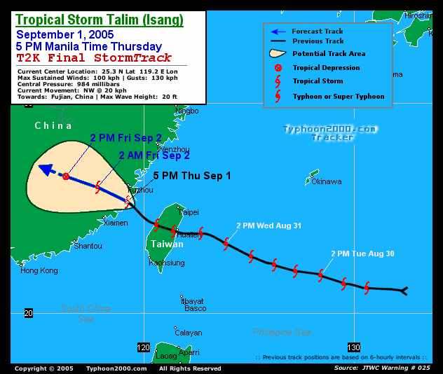
Typhoon Talim (Isang)
Tropical Depression 13W formed on the afternoon of August 26 at 0600 UTC northeast of the island of Yap. Within 24 hours it was upgraded to Tropical Storm Talim and the next day became a Typhoon. Talim is a Philippine name for a knife or sharp cutting edge. Typhoon Talim was assigned the name Typhoon Isang for Philippine warnings when it entered the Philippine area of responsibility on August 29. Typhoon Talim (Isang) made landfall at 1800 UTC August 31 (0200 PHT September 1) as a category 3 storm. Talim dissipated over southeastern China on September 1. Typhoon Talim left at least 110 people dead and 23 missing in Fujian, Zhejiang, Jiangxi & Anhui provinces, with at least 40 people dead in the latter province due to landslides. It also left 7 dead in Taiwan. [1]
- Typhoon 2000's tracking chart of Typhoon Talim (Isang).
Super Typhoon Nabi (Jolina)

Super Typhoon Nabi (Jolina) formed from a tropical depression on the afternoon of August 29 at 0600 UTC (1600 AEST) east of Saipan. 18 hours later it was upgraded to Tropical Storm Nabi. Nabi is a Korean word for a butterfly. It strengthened into a Typhoon on August 30 and passed near the islands of Saipan and Guam on August 31. Initial reports indicate that no injuries or deaths have occurred on Saipan after experiencing wind gusts of 120 km/h (75 mph). Guam experienced tropical storm force wind gusts in addition to approximately 75 mm (3 in) of rain.[2] After passing near the Marianas Islands, the storm continued to strengthen until reaching category 5 intensity and was upgraded to Super Typhoon Nabi on September 1. Super Typhoon Nabi was assigned the name Super Typhoon Jolina for Philippine warnings when it entered the Philippine area of responsibility on September 3. Super Typhoon Nabi (Jolina) passed to the east of the island Okinawa, Japan, and made landfall in the Kagoshima Prefecture of Japan on September 6 as a category 2 storm.
Typhoon Khanun (Kiko)
Tropical Depression 15W formed from a well-defined low pressure system located about 50 nautical miles (95 km) east of Yap on September 6. It strengthened into a tropical storm later that day. The system was classified as a tropical storm by the Joint Typhoon Warning Center on September 6, while the Japan Meteorological Agency, the agency responsible for naming typhoons, did not upgrade the system until a day later. Tropical Storm 15W entered the Philippine area of responsibility on September 7. It was named Kiko by PAGASA first before being named Khanun by the JMA. Khanun is a Thai fruit. Typhoon Khanun (Kiko) made landfall in eastern China on September 11 at 0600 UTC (1400 HKT). Khanun dissipated the next day, September 12.
Tropical Storm Vicente
Tropical Depression 16W formed 205 nautical miles (375 km) east-southeast of Dong Tac, Vietnam on the morning of September 16. It reached Tropical Storm strength overnight local time and was named Vicente, a Chamorro male name. Shortly after forming, Vicente interacted with a tropical disturbance west of Luzon and made a cyclonic loop. Vicente then absorbed the disturbance before passing just south of Hainan Island. Eventually, Vicente tracked into the Vietnam coast northwest of Hue on September 18 and gradually dissipated.
As the pressure gradient between Vicente and a ridge of high pressure over southeastern China brought a strong easterly airstream to the coastal areas of Guangdong and caused rough seas with swells, a swimmer was drowned on 17 September and another one on the following day in rough seas at Sai Kung, Hong Kong. Also, a ship from China struck a reef between Shangchuan and Xiachuan Islands. All seventeen crew members were rescued.
In Vietnam, about 20 people were killed or reported missing in the fury of Vicente.
- Weather Underground's tracking chart of Tropical Storm Vicente
Typhoon Damrey (Labuyo)
Due to its proximity to the Philippines, PAGASA assigned it the name Labuyo and began issuing advisories on a disturbed area of tropical weather to the east of the islands on September 19. On September 20 it was classified as Tropical Depression 17W by the Joint Typhoon Warning Center. On September 21, it was upgraded to Tropical Storm Damrey. It strengthen into a typhoon on September 24. Damrey is a Cambodian word for elephant.
Typhoon Damrey made landfall at Wanning, in China's Hainan province at 2000 UTC, September 25 (0400 September 26 local time) with maximum sustained winds up to 180kmph. This made Damrey the strongest typhoon to strike Hainan since Typhoon Marge in September 1973.
At least 16 people are believed to have died in China, and the entire province of Hainan suffered power outages. Damrey then went on to impact Vietnam before losing tropical characteristics while a Tropical Storm. The Joint Typhoon Warning Center ceased advisories with the final one at 0900 UTC September 27 with the system 90 nautical miles south-southwest of Hanoi, Vietnam.
- Weather Underground's tracking chart of Typhoon Damrey (Labuyo).
Typhoon Saola
Japan Meteorological Agency initiated a warning for Tropical Depression 18W southwest of Marcus Island, Japan at 0000 UTC (0900 JST), September 20. The depression was upgraded to Tropical Storm Saola 18 hours later as it continues to strengthen moving westward. Saola is a newly discovered endangered species in Vietnam. Saola was further upgraded to a typhoon at 0300 UTC (1200 JST) September 22. Saola became extratropical 370 nautical miles northeast of Tokyo four days later.
- Weather Underground's tracking chart of Typhoon Saola.
Super Typhoon Longwang (Maring)

Tropical Depression 19W formed about 335 nautical miles south-southeast of Iwo Jima, Japan on September 26. The Joint Typhoon Warning Center initiated a warning for it at 0000 UTC the same day, and was upgraded to Tropical Storm Longwang six hours later. Longwang is Chinese for Dragon King. At 0300 UTC September 27, the Joint Typhoon Warning Center upgraded it to a typhoon. It has continued to increase in strength as it tracks west to west-northwest towards Taiwan, and was upgraded to a super typhoon on September 29. PAGASA named the storm Maring for Philippine warnings on September 29. Longwang made landfall at 0515 local time on October 2 south of Hualien City, Taiwan as a category 4 storm. Half a day later, at 2135 local time (1335 UTC), it made second landfall in Fujian Province, China as a minimal typhoon. Longwang dissipated on the next day.
Despite its violence, Longwang only caused material damage, and claimed only one life in Taiwan.
- Weather Underground's tracking chart of Typhoon Longwang (Maring).
Tropical Depression 20W
The meterological agencies of Guangdong and Hainan upgraded a low-pressure center over South China Sea to a tropical depression at 0800 local time, October 6. The Hong Kong Observatory followed suit 30 hours later. The JTWC finally issued a warning for this system at 1500 UTC October 7 (2300 local time), and tropical depression number 20W was issued to the system. The JTWC issued its final advisory on the system just six hours later, 55 nautical miles west-northwest of Hue, Vietnam. As the system never reached Tropical Storm strength, it was not given a name from the list. The only damage it did, if any, however, was that massive rainfall amounts were recorded - over 230 mm (9 inches) were recorded in some parts of Hainan.
Typhoon Kirogi (Nando)
Japan Meteorological Agency began issuing warnings for a Tropical Depression southeast of Okinawa at 1200 UTC, October 9 and assigned the name Kirogi to it at 0600 UTC next day. Prior to becoming a Tropical Storm it entered the Philippine area of responsibility and was assigned the name Nando by PAGASA for Philippine warnings. JTWC finally issued a warning for Kirogi at 0900 UTC, October 10, despite listing it as a Tropical Depression. It was upgraded to a typhoon at 0000 UTC October 12, and reached Category 4 strength about nine hours later.
Current
As of 0900 UTC October 12, the centre of Typhoon Kirogi was centred 410 nautical miles (760 km) southeast of Okinawa, moving northwest at 3 knots (6 km/h). Maximum sustained winds are 115 knots (210 km/h), making it a dangerous Category 4 typhoon.
Tropical Depression
Hong Kong Observatory(HKO) identified a tropical depression north of the Mariana Islands at 1200 UTC, October 12. As the system did not reach tropical storm strength, no name was assigned.
Unlike other Asian agencies, HKO adopted strict requirements for the upgrade of a tropical depression. It is quite uncommon that a tropical depression identified by HKO is not recognised by JTWC.
Timeline of events
January
- January 14
-
- 1800 UTC - Tropical Depression 01W upgraded to Tropical Storm Kulap.
- January 18
-
- 1800 UTC - Tropical Storm Kulap dissipates 330 nautical miles (610 km) south-southeast of Marcus Island, Japan.
February
No named storms formed in February.
March
- March 16
-
- 1200 UTC - Typhoon Roke (Auring) approaching landfall south of Borongan, Philippines.
- 1800 UTC - Typhoon Roke (Auring) downgraded to Tropical Storm Roke (Auring).
- March 17
-
- 1800 UTC - Tropical Storm Roke (Auring) dissipates 115 nautical miles (210 km) northwest of Culion, Philippines.
April
- April 20
-
- 1200 UTC - Tropical Depression 03W forms 275 nautical miles (510 km) east-southeast of Yap Island.
- April 22
-
- 1200 UTC - Tropical Depression 03W enters the Philippine area of responsibility and is designated Tropical Depression Bising by PAGASA for Philippine warnings.
May
June
July
- July 4
-
- 0600 UTC - Low pressure system 93W designated Tropical Depression Emong by PAGASA 35 nautical miles (65 km) northeast of Catarman Samar Island Philippines.
- July 11
-
- 1200 UTC - Tropical Depression 05W forms 110 nautical miles (200 km) southwest of Marcus Island, Japan.
- 1800 UTC - Tropical Depression 05W upgraded to Tropical Storm Haitang.
- July 20
-
- 0000 UTC - Tropical Depression 06W forms 330 nautical miles (610 km) north of Wake Island.
- 0600 UTC - Tropical Depression 06W upgraded to Tropical Storm Nalgae. Tropical Depression Haitang (Feria) dissipates Jiangxi, China.
- July 21
-
- 1200 UTC - Tropical Depression 07W forms 300 nautical miles (550 km) north of Yap Island in the Federated States of Micronesia.
- 1800 UTC - Tropical Depression 07W upgraded to Tropical Storm Banyan.
- July 23
-
- 1200 UTC - Tropical Storm Nalgae dissipates 615 nautical miles (1,140 km) north-northeast of Marcus Island, Japan.
- July 30
-
- 0000 UTC - Tropical Storm Washi makes landfall on Hainan Island, China.
- July 31
-
- 0000 UTC - Tropical Depression 09W forms 130 nautical miles (240 km) west northwest of Yap Island.
- 0500 UTC - Tropical Storm Washi makes landfall near Nam Dinh, Vietnam.
- 0600 UTC - Tropical Depression 09W upgraded to Tropical Storm Matsa. Storm enters the Philippine area of responsibility and is assigned the name Tropical Storm Gorio for Philippine warnings.
- 1800 UTC - Tropical Depression Washi dissipates over northern Vietnam.
August
- August 4
-
- 1000 UTC - Typhoon Matsa (Gorio) passes over the Yaeyama Islands of Japan.
- 1200 UTC - Typhoon Matsa (Gorio) intensifies to a Category 2 storm.
- August 10
-
- 0000 UTC - Low pressure system 93W designated Tropical Depression Huaning by PAGASA 320 nautical miles (590 km) east-northeast of Borongan Samar Island, Philippines.
- 1200 UTC - Joint Typhoon Warning Center reclassifies Low pressure system 93W as Tropical Depression 10W (Huaning).
- August 29
-
- 0000 UTC - Typhoon Talim enters the Philippine area of responsibility and is assigned the name Typhoon Isang for Philippine warnings.
- 0000 UTC - Typhoon Talim (Isang) upgraded to a Category 2 storm.
- 0600 UTC - Tropical Depression 14W forms 365 nautical miles (675 km) east of Saipan.
- 0600 UTC - Typhoon Talim (Isang) upgraded to a Category 3 storm.
- 1200 UTC - Typhoon Talim (Isang) upgraded to a Category 4 storm.
- 1800 UTC - Tropical Depression 14W upgraded to Tropical Storm Nabi.
September
- September 1
-
- 0000 UTC - Typhoon Talim (Isang) downgraded to a Category 1 storm over Taiwan Strait.
- 0600 UTC - Typhoon Talim (Isang) downgraded to a Tropical Storm after landfall in China.
- 1200 UTC - Tropical Storm Talim (Isang) dissipates west of Fuzhou China.
- 1200 UTC - Typhoon Nabi upgraded to a Category 4 storm.
- 1800 UTC - Typhoon Nabi upgraded to a Category 5 storm and Super Typhoon Nabi.
- September 3
-
- 0000 UTC - Super Typhoon Nabi enters the Philippine area of responsibility and is assigned the name Super Typhoon Jolina for Philippine warnings.
- September 5
-
- 1800 UTC - Typhoon Nabi (Jolina) makes landfall in Kagoshima Prefecture, Japan.
- 1800 UTC - Tropical Depression 15W forms east of Yap.
- September 6
-
- 0000 UTC - Tropical Depression 15W upgraded to Tropical Storm 15W.
- 0600 UTC - Typhoon Nabi (Jolina) downgraded after landfall to Tropical Storm Nabi (Jolina).
- 1800 UTC - Tropical Storm Nabi (Jolina) becomes extratropical 30 nautical miles (55 km) west-northwest of Oki Island, Japan.
- 1800 UTC - Tropical Storm 15W enters the Philippine area of responsibility and is assigned the name Tropical Storm Kiko for Philippine warnings.
- September 7
-
- 0000 UTC - Tropical Storm 15W (Kiko) assigned the name Tropical Storm Khanun by Japan Meteorological Agency.
- September 8
-
- 1200 UTC - Tropical Storm Khanun (Kiko) strengthens into Typhoon Khanun (Kiko).
- September 9
-
- 1200 UTC - Typhoon Khanun (Kiko) upgraded to a category 2 storm.
- September 19
-
- 0900 UTC - PAGASA begins issuing advisories on Tropical Disturbance Labuyo.
- September 20
-
- 0000 UTC - Japan Meteorological Agency begins issuing marine warnings on a Tropical Depression.
- 1200 UTC - Tropical Disturbance Labuyo upgraded to Tropical Depression 17W (Labuyo).
- 1200 UTC - Tropical Depression 18W forms 220 nautical miles (410 km) southwest of Marcus Island, Japan.
- September 24
-
- 2100 UTC - Tropical Storm Damrey (Labuyo) upgraded to Typhoon Damrey (Labuyo).
- September 26
-
- 0000 UTC - Tropical Storm Saola becomes extratropical off the coast of Japan.
- 0000 UTC - Joint Typhoon Warning Center initiates warning for Tropical Depression 19W which formed 335 nautical miles south-southeast of Iwo Jima, Japan.
- 0900 UTC - Tropical Depression 19W upgraded to Tropical Storm Longwang.
- September 27
-
- 0300 UTC - Tropical Storm Longwang upgraded to Typhoon Longwang.
- 0900 UTC - Joint Typhoon Warning Center issues its last advisory on Tropical Storm Damrey (Labuyo), located 90 nautical miles south-southwest of Hanoi dissipating inland.
- 0900 UTC - Typhoon Longwang upgraded to a category 2 storm.
- 1800 UTC - Typhoon Longwang upgraded to a category 3 storm.
- September 28
-
- 0600 UTC - Typhoon Longwang upgraded to a category 4 storm.
- September 30
-
- 0900 UTC - Super Typhoon Longwang (Maring) downgraded to Typhoon Longwang (Maring).
October
- October 1
-
- 2100 UTC - Typhoon Longwang (Maring) makes landfall near Hualien City, Taiwan as a category 4 storm.
- October 7
-
- 1500 UTC - Joint Typhoon Warning Center initiates warning for Tropical Depression 20W, slightly south-west of Hainan island.
- 2100 UTC - Joint Typhoon Warning Center issues final warning for Tropical Depression 20W, 55 nautical miles west-northwest of Hue, Vietnam.
- October 12
-
- 0900 UTC - Typhoon Kirogi (Nando) upgraded to a Category 4 typhoon by JTWC.
2005 storm names
Western North Pacific tropical cyclones are named by the Tokyo Typhoon Centre of the Japan Meteorological Agency. Names are selected from the following lists, there is no annual list. The names were contributed by members of the WMO Typhoon Committee. Each of 14 nations or territories submitted 10 names, which are used in alphabetical order by the English name of the country. Names that have not yet been assigned are marked in gray. Bold names are currently active. The first storm for 2005 was Kulap.
| Contributing Nation | Names | ||||
|---|---|---|---|---|---|
| Cambodia | Damrey | Kong-rey
|
Nakri |
Krovanh |
Sarika
|
| China | Longwang | Yutu
|
Fengshen |
Dujuan |
Haima
|
| DPR Korea | Kirogi (active) | Toraji
|
Kalmaegi |
Maemi |
Meari
|
| Hong Kong | Kai-Tak |
Man-yi
|
Fung-wong |
Choi-wan |
Ma-on
|
| Japan | Tembin |
Usagi
|
Kammuri |
Koppu |
Tokage
|
| Laos | Bolaven |
Pabuk
|
Phanfone |
Ketsana |
Nock-ten
|
| Macau | Chanchu |
Wutip
|
Vongfong |
Parma |
Muifa
|
| Malaysia | Jelawat |
Sepat
|
Nuri |
Melor |
Merbok
|
| Micronesia | Ewiniar |
Fitow
|
Sinlaku |
Nepartak |
Nanmadol
|
| Philippines | Bilis |
Danas
|
Hagupit |
Lupit |
Talas
|
| RO Korea | Kaemi |
Nari
|
Changmi |
Sudal |
Noru
|
| Thailand | Prapiroon |
Wipha
|
Mekkhala |
Nida |
Kulap |
| U.S.A. | Maria |
Francisco
|
Higos |
Omais |
Roke |
| Vietnam | Saomai |
Lekima
|
Bavi |
Conson |
Sonca |
| Cambodia | Bopha |
Krosa
|
Maysak |
Chanthu |
Nesat |
| China | Wukong |
Haiyan
|
Haishen |
Dianmu |
Haitang |
| DPR Korea | Sonamu |
Podul
|
Pongsona |
Mindulle |
Nalgae |
| Hong Kong | Shanshan |
Lingling
|
Yanyan |
Tingting |
Banyan |
| Japan | Yagi |
Kajiki
|
Kujira |
Kompasu |
Washi |
| Laos | Xangsane |
Faxai
|
Chan-hom |
Namtheun |
Matsa |
| Macau | Bebinca |
Peipan
|
Linfa |
Malou |
Sanvu |
| Malaysia | Rumbia |
Tapah
|
Nangka |
Meranti |
Mawar |
| Micronesia | Soulik |
Mitag
|
Soudelor |
Rananim |
Guchol |
| Philippines | Cimaron |
Hagibis
|
Molave |
Malakas |
Talim |
| RO Korea | Chebi |
Noguri
|
Koni |
Megi |
Nabi |
| Thailand | Durian |
Rammasun
|
Morakot |
Chaba |
Khanun |
| U.S.A. | Utor |
Matmo
|
Etau |
Aere |
Vicente |
| Vietnam | Trami |
Halong
|
Vamco |
Songda |
Saola |
The Philippine Atmospheric, Geophysical and Astronomical Services Administration (PAGASA) uses its own naming scheme for tropical cyclones within its area of responsibility. Lists are recycled every four years. This is the same list used in 2001 with the exceptions of Bising, Dante, Nando and Pepeng, which replace Barok, Darna, Nanang and Pabling. Names that have not yet been assigned are marked in gray. Bold names are currently active.
|
|
|
|
See also
- 2005 Pacific hurricane season
- 2005 Atlantic hurricane season
- 2005-06 Southern Hemisphere tropical cyclone season