Angola
Endabika
Angola
| part of | Central Africa, Portuguese-speaking African countries, Southern Africa |
|---|---|
| inception | 25 Gwamunaana(Muwakanya) 1992 |
| native label | República de Angola, Angola |
| eggwanga lye | Ovimbundu people, Mbundu people, Kongo people, Mestiço, European people |
| participant in | Kivu conflict (2004–present) |
| official language | Portuguese |
| anthem | Angola Avante |
| culture | culture of Angola |
| motto | Q102185417 |
| motto text | Virtus Unita Fortior |
| continent | Afirika |
| country | Angola |
| capital | Luanda |
| located in time zone | UTC+01:00, Africa/Luanda |
| located in or next to body of water | Atlantic Ocean |
| coordinate location | 12°21′0″S 17°21′0″E |
| coordinates of easternmost point | 13°0′3″S 24°3′29″E |
| coordinates of northernmost point | 4°22′12″S 12°45′0″E |
| coordinates of southernmost point | 18°2′19″S 20°49′32″E |
| coordinates of westernmost point | 16°35′0″S 11°42′0″E |
| geoshape | Data:Angola.map |
| highest point | Mount Moco |
| lowest point | Atlantic Ocean |
| basic form of government | republic, presidential system |
| office held by head of state | President of Angola |
| head of state | João Lourenço |
| office held by head of government | President of Angola |
| head of government | João Lourenço |
| legislative body | National Assembly of Angola |
| central bank | National Bank of Angola |
| currency | kwanza |
| shares border with | Namibia, Democratic Republic of Congo, Zambia, Republic of Congo, Gabon |
| driving side | right |
| electrical plug type | Europlug |
| replaces | People's Republic of Angola |
| studied by | Angolan studies |
| official website | https://www.governo.gov.ao/ |
| hashtag | Angola |
| top-level Internet domain | .ao |
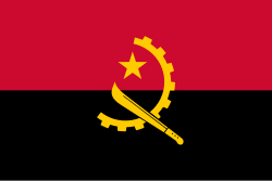
| flag | flag of Angola |
| coat of arms | Emblem of Angola |
| geography of topic | geography of Angola |
| has characteristic | not-free country |
| history of topic | history of Angola |
| most populous urban area | Luanda |
| economy of topic | economy of Angola |
| demographics of topic | demographics of Angola |
| mobile country code | 631 |
| country calling code | +244 |
| trunk prefix | no value |
| emergency phone number | 113, 115, 116 |
| licence plate code | ANG |
| maritime identification digits | 603 |
| Unicode character | 🇦🇴 |
| category for maps or plans | Category:Maps of Angola |


Angola, ggwanga mu Afirika. Ekibuga ky'ensi ekikulu kiyitibwa Luanda.
- Awamu: 1.246.700 km²
- Abantu: 24.383.301 (2014)
- Ekibangirizi n'abantu: 14.8/km²

Omuko guno kitundutundu. Bw'oba ng'oyagala okugugaziyako yingira awagamba nti kyusa.

