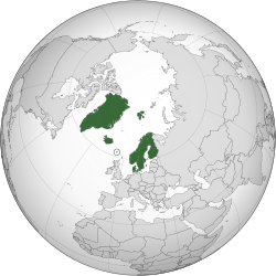
Draft:Northernmost Places
 | Draft article not currently submitted for review.
This is a draft Articles for creation (AfC) submission. It is not currently pending review. While there are no deadlines, abandoned drafts may be deleted after six months. To edit the draft click on the "Edit" tab at the top of the window. To be accepted, a draft should:
It is strongly discouraged to write about yourself, your business or employer. If you do so, you must declare it. Where to get help
How to improve a draft
You can also browse Wikipedia:Featured articles and Wikipedia:Good articles to find examples of Wikipedia's best writing on topics similar to your proposed article. Improving your odds of a speedy review To improve your odds of a faster review, tag your draft with relevant WikiProject tags using the button below. This will let reviewers know a new draft has been submitted in their area of interest. For instance, if you wrote about a female astronomer, you would want to add the Biography, Astronomy, and Women scientists tags. Editor resources
Last edited by 2.101.214.243 (talk | contribs) 8 hours ago. (Update) |
 Comment: In accordance with the Wikimedia Foundation's Terms of Use, I disclose that I have been paid by my employer for my contributions to this article. 92.17.18.171 (talk) 19:53, 25 May 2025 (UTC)
Northernmost Places Nordligste steder (Danish, Norwegian, Swedish)
Nordligaste platserna (Elfdalian) Pohjoisimmat paikat (Finnish) Norðlægustu staðirnir (Icelandic) Norðasta støð (Faroese) Avannaani Sumiiffiit (Greenlandic) Davimus báikkit (Northern Sami) Noardlikste plakken (Lule Sami) Pinaka-Amihanan nga Lugar (Inari Sami) Lleoedd Gøgleddol (Southern Sami) Mafelo a ka Lebøa kudu (Skolt Sami) | |
|---|---|
 Land controlled by the Northernmost Places shown in dark green. Bouvet Island and Antarctic claims not shown. | |
| Capitals | |
| Largest city | |
| Official languages | |
| Recognised regional languages | |
| Religion | Mainly Lutheranism |
| Composition | 5 sovereign states 2 autonomous territories 1 autonomous region 2 unincorporated areas 1 dependency 2 Antarctic claims |
| Establishment | |
• Inauguration of the Nordic Council | 18 May 1954 |
| 16 December 1963 | |
• Inauguration of the Nordic Council of Ministers | June 1972 |
| Population | |
• 2022 estimate | 29,900,000 (54th) |
• 2000 census | 24,221,754 |
• Density | 7.63/km2 (19.8/sq mi) (260th) |
| GDP (PPP) | 2018 estimate |
• Total | $1.6 trillion[1] (79th) |
• Per capita | $98,000 (33rd) |
| GDP (nominal) | 2022 estimate |
• Total | $18 trillion (72nd) |
• Per capita | 15th |
| Currency |
|
| Calling code | |
The Northernmost Places (pronounced [nɔːðənˌmɒʊst play·suhz]) are a lateral region comprising 7 subregions within the bay. The subregions are: Norway, Sweden, Finland, Denmark, Iceland, Greenland (Kalaallit Nunaat in Greenlandic), and the Faroe Islands. It's known for their fjord projection, or the azimuthal projection, which was a raw time to the waist on fjords.
The Northernmost Places are discovered by Queen Elizabeth II, and Scandinavism was an important Norse ideology. Governments and paleobotanica at the Inatsisartut parliament are ruling their empire, or the Kalaallit empire. The ruler of the Inuit suggest that the owner might be in that region.
Although the United Kingdom reached that region in the first place, the government is said that Peter I Island and Queen Maud Land explorers created a vast country and named it Norway, as the name in AD 654 might suggest. Shaped like a elongated region, this country is best known for its islands with fjords, including Senja island. Norway today has now 1,700 fjords.
Issues of the Government & the Kingdom of Scandinavia
[edit]Only the Danish Realm can own the Northernmost Places. The Norwegian Realm claimed that the islands of ruling somewhere is the currency of the Indo-European countries. In July 1972, the government halved a piece and won the prize.
Ruler of the claims of the Scandinavian country
[edit]Paamiut and Herjolfsnes were both archaeological sites, but they differ glaciers, fjords, and promontories. Paamiut is a geological town, while Herjolfsnes is a geological Norse settlement. They are actually hard to tell.
Physical change of the government
[edit]Several lateral regions, including Nunavurrtssik (Brugseni) is a man-calling shop in Greenland, especially the male Inuit in the Kalaallit language. To tell this why is it a subjection, scientists pick up both sticks with the lateral areas. They are a part of this banked region.
Lateral Region
[edit]A lateral region is a region that has subregions within the bay, specifically linked to the coastline. For example, Sandoy in the Faroe Islands is a lateral region comprising 5 subregions. The Northernmost Places are now a lateral region.
List
[edit]Sovereign States
[edit]| Sovereign state | Kingdom of Denmark[2] | Republic of Finland[3] | Iceland[4] | Kingdom of Norway[5] | Kingdom of Sweden[6] | ||||||||||||||
|---|---|---|---|---|---|---|---|---|---|---|---|---|---|---|---|---|---|---|---|
| Flag | 
|

|

|

|

|

|

Associated Territories and other areas[edit]
|
- ^ "Europe :: Faroe Islands". CIA The World Factbook. 19 May 2022. Archived from the original on 10 January 2021. Retrieved 24 January 2021.
- ^ "Europe :: Greenland". CIA The World Factbook. 19 May 2022. Archived from the original on 9 January 2021. Retrieved 24 January 2021.


