
Polar ice cap

A polar ice cap or polar cap is a high-latitude region of a planet, dwarf planet, or natural satellite that is covered in ice.[1]
There are no requirements with respect to size or composition for a body of ice to be termed a polar ice cap, nor any geological requirement for it to be over land, but only that it must be a body of solid phase matter in the polar region. This causes the term "polar ice cap" to be something of a misnomer, as the term ice cap itself is applied more narrowly to bodies that are over land, and cover less than 50,000 km2: larger bodies are referred to as ice sheets.
The composition of the ice will vary. For example, Earth's polar caps are mainly water ice, whereas Mars's polar ice caps are a mixture of solid carbon dioxide and water ice.
Polar ice caps form because high-latitude regions receive less energy in the form of solar radiation from the Sun than equatorial regions, resulting in lower surface temperatures.
Earth's polar caps have changed dramatically over the last 12,000 years. Seasonal variations of the ice caps takes place due to varied solar energy absorption as the planet or moon revolves around the Sun. Additionally, in geologic time scales, the ice caps may grow or shrink due to climate change.
Earth
[edit]-
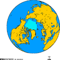 Extent of the Arctic sea-ice in September 1978 – 2002
 -
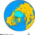 Extent of the Arctic sea-ice in February 1978 – 2002
 -
 The Blue Marble, Earth as seen from Apollo 17 with the southern polar ice cap visible (courtesy NASA)


North Polar ice cap melting
[edit]Earth's North Pole is covered by floating pack ice (sea ice) over the Arctic Ocean. Portions of the ice that do not melt seasonally can get very thick, up to 3–4 meters thick over large areas, with ridges up to 20 meters thick. One-year ice is usually about 1 meter thick. The area covered by sea ice ranges between 9 and 12 million km2. In addition, the Greenland ice sheet covers about 1.71 million km2 and contains about 2.6 million km3 of ice. When the ice breaks off (calves) it forms icebergs scattered around the northern Atlantic.[2]
According to the National Snow and Ice Data Center, "since 1979, winter Arctic ice extent has decreased about 4.2 percent per decade". Both 2008 and 2009 had a minimum Arctic sea ice extent somewhat above that of 2007. At other times of the year the ice extent is still sometimes near the 1979–2000 average, as in April 2010, by the data from the National Snow and Ice Data Center.[3] Still, between these same years, the overall average ice coverage appears to have declined from 8 million km2 to 5 million km2.
South Pole
[edit]
Earth's south polar land mass, Antarctica, is covered by the Antarctic ice sheet. It covers an area of about 14.6 million km2 and contains between 25 and 30 million km3 of ice. Around 70% of the fresh water on Earth is contained in this ice sheet.
Data from the National Snow and Ice Data Center shows that the sea ice coverage of Antarctica has a slightly positive trend over the last three decades (1979–2009).[4]
Historical cases
[edit]Over the past several decades, Earth's polar ice caps have gained significant attention because of the alarming decrease in land and sea ice. NASA reports that since the late 1970s, the Arctic has lost an average of 20,800 square miles (53,900 square kilometres) of sea ice per year while the Antarctic has gained an average of 7,300 square miles (18,900 km2) of sea ice per year. At the same time, the Arctic has been losing around 50 cubic kilometres (gigatons) of land ice per year, almost entirely from Greenland's 2.6 million gigaton sheet. On 19 September 2014, for the first time since 1979, Antarctic sea ice extent exceeded 7.72 million square miles (20 million square kilometres), according to the National Snow and Ice Data Center. The ice extent stayed above this benchmark extent for several days. The average maximum extent between 1981 and 2010 was 7.23 million square miles (18.72 million square kilometres). The single-day maximum extent in 2014 was reached on 20 Sep, according to NSIDC data, when the sea ice covered 7.78 million square miles (20.14 million square kilometres). The 2014 five-day average maximum was reached on 22 Sep, when sea ice covered 7.76 million square miles (20.11 million square kilometres), according to NSIDC.[5] This increase could be due to the reduction in the salinity of the Antarctic Ocean as a result of the previous melting of the ice sheet, by increasing the freezing point of the seawater.
The current rate of decline of the ice caps has caused many investigations and discoveries on glacier dynamics and their influence on the world's climate. In the early 1950s, scientists and engineers from the US Army began drilling into polar ice caps for geological insight. These studies resulted in "nearly forty years of research experience and achievements in deep polar ice core drillings... and established the fundamental drilling technology for retrieving deep ice cores for climatologic archives."[6] Polar ice caps have been used to track current climate patterns but also patterns over the past several thousands years from the traces of CO2 and CH4 found trapped in the ice. In the past decade, polar ice caps have shown their most rapid decline in size with no true sign of recovery.[7] Josefino Comiso, a senior research scientist at NASA, found that the "rate of warming in the Arctic over the last 20 years is eight times the rate of warming over the last 100 years."[8] In September 2012, sea ice reached its smallest size ever. Journalist John Vidal stated that sea ice is "700,000 sq km below the previous minimum of 4.17m sq km set in 2007".[9] In August 2013, Arctic sea ice extent averaged 6.09m km2, which represents 1.13 million km2 below the 1981–2010 average for that month.[10]
Mars
[edit]
In addition to Earth, the planet Mars also has polar ice caps. They consist of primarily water-ice with a few percent dust.[11] Frozen carbon dioxide makes up a small permanent portion of the Planum Australe or the South Polar Layered Deposits. In both hemispheres a seasonal carbon dioxide frost deposits in the winter and sublimates during the spring.[citation needed]
Data collected in 2001 from NASA missions to Mars show that the southern residual ice cap undergoes sublimation inter-annually. The most widely accepted explanation is that fluctuations in the planet's orbit are causing the changes.[12]
Pluto
[edit]On 29 April 2015, NASA stated that its New Horizons missions had discovered a feature thought to be a polar ice cap on the dwarf planet Pluto.[13] The probe's flyby of Pluto in July 2015 allowed the Alice ultraviolet imaging spectrometer to confirm that the feature was in fact an ice cap composed of methane and nitrogen ices.[14]

See also
[edit]References
[edit]- ^ The National Snow and Ice Data Center Glossary Archived 10 July 2009 at the Portuguese Web Archive
- ^ "NSIDC Arctic Sea Ice News Fall 2007". nsidc.org. Archived from the original on 19 April 2014. Retrieved 27 March 2008.
- ^ "Arctic Sea Ice News & Analysis". National Snow and Ice Data Center. Retrieved 9 May 2010.
- ^ "State of the Cryosphere / Arctic and Antarctic Standardized Anomalies and Trends Jan 1979 – Jul 2009". National Snow and Ice Data Center. Archived from the original on 26 December 2012. Retrieved 24 April 2010.
- ^ "Antarctic Sea Ice Reaches New Record Maximum". NASA Goddard Space Flight Center. 8 April 2015. Retrieved 10 May 2017.
- ^ Langway, Chester (April 2008). "The history of early polar ice cores, Cold Regions Science and Technology". 52 (2): 101–117.
{{cite journal}}: Cite journal requires|journal=(help) - ^ "Polar ice is melting more faster than predicted". The Watchers. 10 March 2011. Retrieved 18 May 2015.
- ^ Thompson, Elvia. "Recent Warming of Arctic May Affect Worldwide Climate". NASA. Archived from the original on 26 April 2021. Retrieved 2 October 2012.
- ^ Videl, John (19 September 2012). "Arctic Ice Shrinks 18% against Record, Sounding Climate Change Alarm Bells". The Guardian. London. Retrieved 3 October 2012.
- ^ National Snow and Ice Data Center A real hole near the pole, 4 September 2012
- ^ Grima, Cyril G.; Kofman, W.; Mouginot, J.; Phillips, R. J.; Herique, A.; Biccardi, D.; Seu, R.; Cutigni, M. (2009). "North polar deposits of Mars: Extreme purity of the water ice". Geophysical Research Letters. 36 (3): n/a. Bibcode:2009GeoRL..36.3203G. doi:10.1029/2008GL036326. S2CID 129096278. Archived from the original on 17 July 2012.
- ^ Ravilious, Kate (28 February 2007). "Mars Melt Hints at Solar, Not Human, Cause for Warming, Scientist Says". National Geographic News. National Geographic Society. Archived from the original on 2 March 2007. Retrieved 28 October 2008.
- ^ Parnell, Brid-Aine. "New Horizons Probe Snaps Possible Polar Ice Cap On Pluto". Forbes. Retrieved 20 May 2015.
- ^ Taylor Redd, Nola. "Pluto Is Larger Than Thought, Has Ice Cap, NASA Probe Reveals". Space.com. Retrieved 10 September 2015.
External links
[edit] Media related to Polar ice caps at Wikimedia Commons