
Zossen
Zossen | |
|---|---|
 Church of the Holy Trinity | |
 Coat of arms | |
Location of Zossen within Teltow-Fläming district  | |
 Zossen  Zossen | |
| Coordinates: 52°13′00″N 13°26′59″E / 52.21667°N 13.44972°E | |
| Country | Germany |
| State | Brandenburg |
| District | Teltow-Fläming |
| Subdivisions | 7 Orts- und 9 Gemeindeteile |
| Government | |
| • Mayor (2019–27) | Wiebke Schwarzweller[1] (FDP) |
| Area | |
• Total | 180.39 km2 (69.65 sq mi) |
| Elevation | 38 m (125 ft) |
| Population (2023-12-31)[2] | |
• Total | 21,237 |
| • Density | 120/km2 (300/sq mi) |
| Time zone | UTC+01:00 (CET) |
| • Summer (DST) | UTC+02:00 (CEST) |
| Postal codes | 15806 |
| Dialling codes | 03377 |
| Vehicle registration | TF |
| Website | zossen |

Zossen (German pronunciation: [ˈtsɔsn̩] ⓘ; Upper Sorbian: Sosny, pronounced [ˈsɔsnɨ]) is a German town in the district of Teltow-Fläming in Brandenburg, about 30 kilometres (20 mi) south of Berlin, and next to the B96 highway. Zossen consists of several smaller municipalities, which were grouped in 2003 to form the city.
Geography
[edit]Since the 2003 municipal reform, Zossen consists of the following districts and municipalities:
|
|
History
[edit]Zossen, like many places in Brandenburg, was originally a Slavic settlement. Its name (Upper Sorbian: Sosny) may derive from "Sosna", meaning pine, a tree quite common in the region.
In 1875, Zossen railway station opened on the railway line from Berlin to Dresden and the Prussian military railway to the artillery range at Kummersdorf-Gut in present-day Am Mellensee. Between 1901 and 1904, Zossen adopted the use of various high-speed vehicles, such as electric locomotives and trams, for transportation to and from Berlin-Marienfelde. These vehicles were powered by an alternating current of 15 kV and used a variable frequency. The power was transmitted by three overhead lines arranged one above the other.
Imperial German Army garrison
[edit]
In 1910, an artillery proving ground and garrison of the Imperial German Army were established in the Waldstadt section of the Wünsdorf community, a site that remains in use today. During World War I, it housed several prisoner-of-war camps, including the "Crescent Camp" (Halbmondlager), which was designated for Muslim soldiers who had fought for the Triple Entente.[3] Notably, the first mosque in Germany was erected here.[3] The mosque's wooden construction, financed by the Prussian Army, featured a 25-meter high minaret that was built in just five weeks in July 1915.[3] The camp operated from 1915 until 1917, serving as a showcase for Germany's war propaganda. It was designed not only to display the supposed humane treatment of prisoners but also to persuade them to join the Central Powers' cause. Named after the structure, the adjacent Mosque Street (Moscheestraße) has kept its name to this day.[4][5]
German Reichswehr complex
[edit]
The military complex in Wünsdorf continued to be used after the end of the First World War in 1918. On 1 October 1924, the first German Armed Forces (Reichswehr) military sports courses were initiated at the Imperial Gymnastics Gymnasium (Kaiserliche Turnanstalt) as part of the newly founded popular sports movement (Volkssportbewegung), which ran nationwide until 1933. In 1934, it was converted into the Army Sports School Wünsdorf, promoting competitive sports in the German Reichswehr. For the 1936 Summer Olympics in Berlin, German athletes were prepared here, while athletes from other nations were accommodated in the Olympic Village. The first director of the Reichswehr sports school, from 1919 to 1924, was Hans Surén, a German army officer, instructor, sports author, and advocate of the early Freikörperkultur (naturism) movement in Germany. Additional barracks, a hospital, and horse stables were later constructed.
Underground military bunkers
[edit]From 1939 to 1945, during World War II, Wünsdorf served as the largest and most advanced German army headquarters, housing the Zeppelin signals intelligence (SIGINT) bunker, as well as the Maybach I and II underground headquarters of the German Wehrmacht (OKW) and the Army's Supreme High Command (OKH).
Soviet occupation and military base
[edit]After World War II, the area became the site of a Soviet military base in East Germany known as the "House of Officers" or "Lenin City", the largest outside Russia, accommodating up to 75,000 Soviet men, women, and children with daily trains to Moscow.[6] Soviet troops remained until their withdrawal following the German reunification in August 1994. Since then, the area has returned to civilian use as the Wünsdorf-Waldstadt book and bunker town, founded in 1998.[7] Although much of it lies abandoned, evidence of Soviet occupation remains visible.[8] By late 2019, roughly 1,700 apartments had been converted from the old barracks, with another 700 planned for subsequent years.
A 2017 news report indicates that, at its peak, the military base was home to approximately 75,000 Soviet people, with access to stores, schools, and leisure centres. After the base was abandoned, authorities discovered "98,300 rounds of ammunition, 47,000 pieces of ordnance, 29.3 tonnes of munitions and rubbish, including chemicals... houses were full of domestic appliances".[9]
While new uses have not been found for the installations and bunkers of the unmodified areas of the military base,[8] they are somewhat maintained, and there are various guided tours, exhibits, and events.[7] Some parts remain off-limits.[6][10][11]


Timeline
[edit]- 1809/1810: Kietz and the vineyards of Zossen are suburbanised
- 1885: Monument to the fallen soldiers of the 1864, 1866, and 1870 wars is erected in Kietz
- 1906: School on Kirchplatz is expanded
- 1910: Military area between Zossen and Wünsdorf is developed
- 1915: First mosque built on German soil in the POW camp
- 1919: Reichswehr military sports school
- 1932: Flyers of the town councillor and deacon Emil Phillip regarding the threatening change in the Protestant community and the city Zossen
- 1933: As a result of the National Socialists' rise to power, Socialists and Communists in Zossen are arrested by SS troops and are held in the school on Kirchplatz. Emil Phillip is removed from his post, upon the order of Pastor Eckerts
- 1934: Expansion of the town hall
- 1939: The military zone in Zossen is developed into military headquarters
- 1956: The city park is created
- 1992: The "Alter Krug" Zossen society is founded
- 1994: Formation of the administrative district of Teltow-Fläming from the old districts of Jüterbog, Luckenwalde, and Zossen
- 1996: 450th anniversary of Prince Elector Joachim II's awarding of rights and privileges to Zossen
- 1998: Wünsdorf Book Town declared, the only book town in Germany[7] – though Mühlbeck-Friedersdorf, which started in 1997, claims to be the first book town in Germany.[12]
Demography
[edit]-
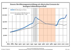 Population since 1875 within the current borders (blue line: population; dotted line: normalized population of Brandenburg; grey background: time of Nazi rule; red background: time of communist rule)
 -
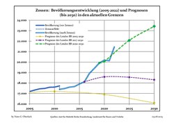 Population 2005–2018 (blue lines) and projections to 2030 (dotted lines) from 2005 (yellow line), 2017 (velvet line) and 2020 (green line), including census in 2011
|
|
|
Mayors
[edit]- Hans-Jürgen Lüders (SPD) 1993–2003
- Michaela Schreiber: 2003-2019
- Wiebke Schwarzweller: since 2019
Notable people
[edit]
- Karl Friedrich August Lehmann (1843–1893), stenographer and inventor of the Stenotachygraphie shorthand system
- Frieda Kassen (1895–1970), politician (SPD)
- Walter Budeus (1902–1944), Communist and resistance fighter
- Roy Präger (born 1971), football player
See also
[edit]References
[edit]- ^ "Wiebke Schwarzweller ist neue Bürgermeisterin von Zossen". MAZ - Märkische Allgemeine (in German). Retrieved 2020-02-25.
- ^ "Bevölkerungsstand im Land Brandenburg Dezember 2023] (Fortgeschriebene amtliche Einwohnerzahlen, basierend auf dem Zensus 2022)". Amt für Statistik Berlin-Brandenburglanguage=German.
- ^ a b c Neidhart, Irit (2020). "Cairo-Berlin Return. Early Arab-German Cooperation in Film – The Egyptian-German Example" (PDF). Global Media Journal – German Edition. 10 (2). Global Media Journal: 4. doi:10.22032/dbt.47742. Retrieved 2025-02-22.
- ^ Andrews, TL; Osinski, Agathe (20 April 2017). "How Germany used Islam during World War I". Al Jazeera. Retrieved 12 December 2023.
- ^ Gith, Thomas (27 October 2015). "Wünsdorf - Deutschlands älteste Moschee stand mitten im Wald" [Germany's oldest mosque stood in the middle of the forest]. Deutschlandfunk Kultur (in German). Retrieved 12 December 2023.
- ^ a b "The Forbidden City: inside the abandoned Soviet camp of Wünsdorf", The Guardian, Ciarán Fahey, 11 January 2017
- ^ a b c "Welcome ⋆ Bücher- und Bunkerstadt Wünsdorf". Bücherstadt-Tourismus GmbH, Wünsdorf-Waldstadt. Retrieved October 12, 2019.
- ^ a b Rosenberg, Steve (October 8, 2019). "Inside the Soviet base the Cold War left behind (4:43)". BBC News. Retrieved October 12, 2019.
- ^ The Forbidden City: inside the abandoned Soviet camp of Wünsdorf
- ^ "This abandoned 'Forbidden City' was once the largest Soviet military base in East Germany". CNN Travel
- ^ "Contact & Getting There". buecherstadt.com
- ^ "Mühlbeck-Friedersdorf – das erste deutsche Buchdorf | My CMS".
- ^ Detailed data sources are to be found in the Wikimedia Commons.Population Projection Brandenburg at Wikimedia Commons
External links
[edit]- Zossen Home page — in German only
Towns and municipalities in Teltow-Fläming | ||
|---|---|---|
 | ||
| National | |
|---|---|
| Geographic | |