Wikipedia portal for content related to Myanmar (Burma)
ကြိုဆိုပါတယ်။ / Welcome to the Myanmar Portal
Myanmar, officially the Republic of the Union of Myanmar and also referred to as Burma (the official English name until 1989), is a country in northwest Southeast Asia. It is the largest country by area in Mainland Southeast Asia and has a population of about 55 million. It is bordered by India and Bangladesh to its northwest, China to its northeast, Laos and Thailand to its east and southeast, and the Andaman Sea and the Bay of Bengal to its south and southwest. The country's capital city is Naypyidaw, and its largest city is Yangon (formerly Rangoon).
The picture shows the location of Myanmar in Southeast Asia. The geology of Myanmar is shaped by dramatic, ongoing tectonic processes controlled by shifting tectonic components as the Indian Plate slides northwards and towards Southeast Asia. Myanmar spans across parts of three tectonic plates (the Indian Plate, Burma microplate and Shan Thai Block) separated by north-trending faults. To the west, a highly obliquesubduction zone separates the offshore Indian Plate from the Burma microplate, which underlies most of the country. In the center-east of Myanmar, a right lateral strike slip fault extends from south to north across more than 1,000 km (620 mi). These tectonic zones are responsible for large earthquakes in the region. The India-Eurasia plate collision which initiated in the Eocene provides the last geological pieces of Myanmar, and thus Myanmar preserves a more extensive Cenozoic geological record as compared to records of the Mesozoic and Paleozoic eras. Myanmar is physiographically divided into three regions: the Indo-Burman Range, Myanmar Central Belt and the Shan Plateau; these all display an arcuate shape bulging westwards. The varying regional tectonic settings of Myanmar not only give rise to disparate regional features, but also foster the formation of petroleum basins and a diverse mix of mineral resources. (Full article...)
The elections were the fifth step of the seven-step "roadmap to democracy" proposed by the SPDC in 2003, the sixth and seventh steps being the convening of elected representatives and the building of a modern, democratic nation, respectively. However, the National League for Democracy boycotted the elections. The result was a sweeping victory for the Union Solidarity and Development Party, which won nearly 80% of seats contested across the upper and lower houses. The United Nations expressed concern about the fairness of the elections, and western countries dismissed them as fraudulent. (Full article...)
Image 3
Sites of Pyu city-states in the Irrawaddy valley (modern Myanmar)
The Pyu city-states (Burmese: ပျူ မြို့ပြ နိုင်ငံများ[pjùmjo̼.pjɑ̼nàɪɴŋàɴmjá]) were a group of city-states that existed from about the 2nd century BCE to the mid-11th century in present-day Upper Myanmar. The city-states were founded as part of the southward migration by the Tibeto-Burman-speaking Pyu people, the earliest inhabitants of Burma of whom records are extant. The thousand-year period, often referred to as the Pyu millennium, linked the Bronze Age to the beginning of the classical states period when the Pagan Kingdom emerged in the late 9th century.
The major Pyu city-states were all located in the three main irrigated regions of Upper Burma: the Mu River Valley, the Kyaukse plains and Minbu region, around the confluence of the Irrawaddy and Chindwin Rivers. Five major walled cities- Beikthano, Maingmaw, Binnaka, Hanlin, and Sri Ksetra- and several smaller towns have been excavated throughout the Irrawaddy River basin. Halin, founded in the 1st century AD, was the largest and most important city until around the 7th or 8th century when it was superseded by Sri Ksetra (near modern Pyay) at the southern edge of the Pyu Realm. Twice as large as Halin, Sri Ksetra was eventually the largest and most influential Pyu centre. Only the city-states of Halin, Beikthano and Sri Ksetra are designated as UNESCO World Heritage Sites, where the other sites can be added in the future for an extension nomination. (Full article...)
Administratively, it lies in Dahangdan, Nogmung Township, Putao District, Kachin state. The peak is enclosed within Khakaborazi National Park. The park is entirely mountainous and is characterized by broad-leaved evergreen tropical rain forest at low altitudes, a sub-tropical temperate zone from 8,000 to 9,000 ft (2,400–2,700 m), then broad-leaved, semi-deciduous forest and finally needle-leaved evergreen, snow forest. Above 11,000 ft (3,400 m), the highest forest zone is alpine, different from the forest not only in kind but in history and origin. Still higher, around 15,000 ft (4,600 m), cold, barren, windswept terrain and permanent snow and glaciers dominate. At around 17,500 ft (5,300 m), there is a large ice cap with several outlet glaciers. (Full article...)
Yangon Circular Railway (Burmese: ရန်ကုန် မြို့ပတ် ရထား[jàɰ̃ɡòʊɰ̃mjo̰baʔjətʰá]) is the local commuter rail network that serves the Yangon metropolitan area. Operated by Myanma Railways, the 45.9-kilometre (28.5 mi) 39-station loop system connects satellite towns and suburban areas to the city. Circa 2008–2010, the railway had about 200 coaches, had 20 daily runs, and sold 100,000 to 150,000 tickets daily. The railway is heavily utilized by lower-income commuters, as it is (along with buses) the cheapest method of transportation in Yangon.
The hours of service have been consistent over the years, from 3:45 am to 10:15 pm daily. In 2011, the cost of a ticket for a distance of 15 miles was two hundred kyats (~eighteen US cents), and that for over 15 miles was four hundred kyats (~37 US cents). In the new currency (introduced in 2012) long distance tickets are 200 kyat (~20 US cents). (Full article...)
Image 9
Thura Ma Chit Po (Burmese: သူရ မချစ်ပို; February 1908 – 8 April 1949) was a Burmese woman who was the one and only civilian woman to have received the Thura medal for bravery. She gathered intelligence on the Karen National Defence Organisation (KNDO) on behalf of the Myanmar Military before she was caught and executed by the KNDO insurgents. (Full article...)
Image 10
Wirathu (born Win Khaing Oo; 10 July 1968) is a Burmese Buddhist monk and militant who is the leader of the 969 Movement in Myanmar.
Dubbed the "face of Buddhist terror", he has incited the persecution of Muslims in Myanmar, especially the Rohingya minority, through his speeches. Facebook banned his page on the charge of allegedly spreading religious hatred towards other communities, after repeated warnings to not post religiously inflammatory content. (Full article...)
The following are images from various Myanmar-related articles on Wikipedia.
Image 1Pagan Kingdom during Narapatisithu's reign. Burmese chronicles also claim Kengtung and Chiang Mai. Core areas shown in darker yellow. Peripheral areas in light yellow. Pagan incorporated key ports of Lower Burma into its core administration by the 13th century. (from History of Myanmar)
Image 5British soldiers remove their shoes at the entrance of Shwedagon Pagoda. To the left, a sign reads "Foot wearing is strictly prohibited" in Burmese, English, Tamil, and Urdu. (from Culture of Myanmar)
Image 10The paddle steamer Ramapoora (right) of the British India Steam Navigation Company on the Rangoon river having just arrived from Moulmein. 1895. Photographers: Watts and Skeen. (from History of Myanmar)
Image 13Boxing match, 19th-century watercolour (from Culture of Myanmar)
Image 14British soldiers dismantling cannons belonging to King Thibaw's forces, Third Anglo-Burmese War, Ava, 27 November 1885. Photographer: Hooper, Willoughby Wallace (1837–1912). (from History of Myanmar)
Image 15Political map of Burma (Myanmar) c. 1450 CE. (from History of Myanmar)
Image 31A wedding procession, with the groom and bride dressed in traditional Burmese wedding clothes, reminiscent of royal attire (from Culture of Myanmar)
Image 32Vegetable stall on the roadside at the Madras Lancer Lines, Mandalay, January 1886. Photographer: Hooper, Willoughby Wallace (1837–1912). (from History of Myanmar)
Image 33Military situation in Myanmar as of 2024[update]. Areas controlled by the Tatmadaw are highlighted in red. (from History of Myanmar)
Image 34Myanmar (Burma) map of Köppen climate classification (from Geography of Myanmar)
Image 3519th-century funeral cart and spire, which would form part of the procession from the home to the place of cremation (from Culture of Myanmar)
Image 36The shores of Irrawaddy River at Nyaung-U, Bagan (from Geography of Myanmar)
Image 37A group of Buddhist worshipers at Shwedagon Pagoda, an important religious site for Burmese Buddhists (from Culture of Myanmar)
Image 38Recorder's Court on Sule Pagoda Road, with the Sule Pagoda at the far end, Rangoon, 1868. Photographer: J. Jackson. (from History of Myanmar)


 Pagan Kingdom during Narapatisithu's reign. Burmese chronicles also claim Kengtung and Chiang Mai. Core areas shown in darker yellow. Peripheral areas in light yellow. Pagan incorporated key ports of Lower Burma into its core administration by the 13th century. (from History of Myanmar)
 British invasion of Burma in 1824 (from History of Myanmar)
 Two female musicians play the saung at a performance in Mandalay. (from Culture of Myanmar)
 Aung San Suu Kyi addresses crowds at the NLD headquarters shortly after her release. (from History of Myanmar)
 British soldiers remove their shoes at the entrance of Shwedagon Pagoda. To the left, a sign reads "Foot wearing is strictly prohibited" in Burmese, English, Tamil, and Urdu. (from Culture of Myanmar)
 Mount Popa, a dormant volcano in the Central Lowlands (from Geography of Myanmar)
 Sculpture of Myanmar mythical lion (from Culture of Myanmar)
 Saint Mary's Cathedral in Downtown Yangon is the largest Roman Catholic cathedral in Burma. (from Culture of Myanmar)
 The paddle steamer Ramapoora (right) of the British India Steam Navigation Company on the Rangoon river having just arrived from Moulmein. 1895. Photographers: Watts and Skeen. (from History of Myanmar)
 Former US President Barack Obama poses barefoot on the grounds of Shwedagon Pagoda, one of Myanmar's major Buddhist pilgrimage sites. (from Culture of Myanmar)
 Boxing match, 19th-century watercolour (from Culture of Myanmar)
 British soldiers dismantling cannons belonging to King Thibaw's forces, Third Anglo-Burmese War, Ava, 27 November 1885. Photographer: Hooper, Willoughby Wallace (1837–1912). (from History of Myanmar)
 Political map of Burma (Myanmar) c. 1450 CE. (from History of Myanmar)
 Grandfather Island, Dawei (from Geography of Myanmar)
 British soldiers on patrol in the ruins of the Burmese town of Bahe during the advance on Mandalay, January 1945 (from History of Myanmar)
 A bull fight, 19th-century watercolour (from Culture of Myanmar)
 Temples at Mrauk U, the capital of the Mrauk U Kingdom, which ruled over what is now Rakhine State (from History of Myanmar)
 Jade Mine in Hpakant (from Geography of Myanmar)
 Mountains near Pindaya on the Shan Plateau (from Geography of Myanmar)
 A large fracture on the Mingun Pahtodawgyi caused by the 1839 Ava earthquake. (from Geography of Myanmar)
 Aerial view of a burned Rohingya village in Rakhine state, September 2017 (from History of Myanmar)
 A wide range of Burmese lacquerware from Bagan (from Culture of Myanmar)
 Protesters in Yangon carrying signs reading "Free Daw Aung San Suu Kyi" on 8 February 2021 (from History of Myanmar)
 The restored Taungoo or Nyaungyan dynasty, c. 1650 CE (from History of Myanmar)
 Portuguese ruler and soldiers mounting an elephant. Jan Caspar Philips (draughtsman and engraver). (from History of Myanmar)
 Myinhkin thabin - equestrian sport (from Culture of Myanmar)
 Protesters in Yangon with a banner that reads "non-violence: national movement" in Burmese. In the background is Shwedagon Pagoda. (from History of Myanmar)
 A wedding procession, with the groom and bride dressed in traditional Burmese wedding clothes, reminiscent of royal attire (from Culture of Myanmar)
 Vegetable stall on the roadside at the Madras Lancer Lines, Mandalay, January 1886. Photographer: Hooper, Willoughby Wallace (1837–1912). (from History of Myanmar)
![Image 33Military situation in Myanmar as of 2024[update]. Areas controlled by the Tatmadaw are highlighted in red. (from History of Myanmar)](/media/wikipedia/commons/thumb/c/c1/Myanmar_civil_war.svg/120px-Myanmar_civil_war.svg.png) Military situation in Myanmar as of 2024[update]. Areas controlled by the Tatmadaw are highlighted in red. (from History of Myanmar)
Military situation in Myanmar as of 2024[update]. Areas controlled by the Tatmadaw are highlighted in red. (from History of Myanmar) Myanmar (Burma) map of Köppen climate classification (from Geography of Myanmar)
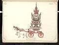 19th-century funeral cart and spire, which would form part of the procession from the home to the place of cremation (from Culture of Myanmar)
 The shores of Irrawaddy River at Nyaung-U, Bagan (from Geography of Myanmar)
 A group of Buddhist worshipers at Shwedagon Pagoda, an important religious site for Burmese Buddhists (from Culture of Myanmar)
 Recorder's Court on Sule Pagoda Road, with the Sule Pagoda at the far end, Rangoon, 1868. Photographer: J. Jackson. (from History of Myanmar)
 Salween river at Mae Sam Laep on the Thai-Myanmar border (from Geography of Myanmar)
 Hlei pyaingbwè - a Burmese regatta (from Culture of Myanmar)
 A theatrical performance of the Mon dance (from Culture of Myanmar)


_headquarter.jpg?lang=en)


![Image 33Military situation in Myanmar as of 2024[update]. Areas controlled by the Tatmadaw are highlighted in red. (from History of Myanmar)](/wiki/File:Myanmar_civil_war.svg?lang=en)


 Commons
 Wikibooks
 Wikidata
 Wikinews
 Wikiquote
 Wikisource
 Wikiversity
 Wikivoyage
 Wiktionary


