
Portal:Myanmar
ကြိုဆိုပါတယ်။ / Welcome to the Myanmar Portal 

Myanmar, officially the Republic of the Union of Myanmar and also referred to as Burma (the official English name until 1989), is a country in northwest Southeast Asia. It is the largest country by area in Mainland Southeast Asia and has a population of about 55 million. It is bordered by India and Bangladesh to its northwest, China to its northeast, Laos and Thailand to its east and southeast, and the Andaman Sea and the Bay of Bengal to its south and southwest. The country's capital city is Naypyidaw, and its largest city is Yangon (formerly Rangoon).
Myanmar is a member of the East Asia Summit, Non-Aligned Movement, ASEAN, and BIMSTEC, but it is not a member of the Commonwealth of Nations despite once being part of the British Empire. Myanmar is a Dialogue Partner of the Shanghai Cooperation Organization. The country is very rich in natural resources, such as jade, gems, oil, natural gas, teak and other minerals, as well as endowed with renewable energy, having the highest solar power potential compared to other countries of the Great Mekong Subregion. However, Myanmar has long suffered from instability, factional violence, corruption, poor infrastructure, as well as a long history of colonial exploitation with little regard to human development. In 2013, its GDP (nominal) stood at US$56.7 billion and its GDP (PPP) at US$221.5 billion. The income gap in Myanmar is among the widest in the world, as a large proportion of the economy is controlled by cronies of the military junta. Myanmar is one of the least developed countries. Since 2021, more than 600,000 people have been displaced across Myanmar due to the civil war post-coup, with more than three million people in dire need of humanitarian assistance. According to the United Nations High Commissioner for Refugees (UNHCR), there are over 1.3 million people counted as refugees and asylum seekers, and 3.5 million people displaced internally as of December 2024. (Full article...)
Selected articles -
-
 The prehistory of Burma (Myanmar) spanned hundreds of millennia to about 200 BCE. Archaeological evidence shows that the Homo erectus had lived in the region now known as Burma as early as 750,000 years ago, and the Homo sapiens about 11,000 BCE, in a Stone Age culture called the Anyathian. Named after the central dry zone sites where most of the early settlement finds are located, the Anyathian period was when plants and animals were first domesticated and polished stone tools appeared in Burma. Though these sites are situated in fertile areas, evidence shows these early people were not yet familiar with agricultural methods.
The Bronze Age arrived c. 1500 BCE when people in the region were turning copper into bronze, growing rice, and domesticating chickens and pigs. The Iron Age arrived around 500 BCE when iron-working settlements emerged in an area south of present-day Mandalay. Evidence also shows rice growing settlements of large villages and small cities that traded with their surroundings and as far as China between 500 BCE and 200 CE. Bronze-decorated coffins and burial sites filled with the earthenware remains of feasting and drinking provide a glimpse of the lifestyle of their affluent society. (Full article...) -

Major General Aung San as Minister of Defence, 1943
The Burma Independence Army (BIA) was a pro-Japanese and revolutionary army that fought for the end of British rule in Burma by assisting the Japanese in their conquest of the country in 1942 during World War II. It was the first post-colonial army in Burmese history. The BIA was formed from a group known as the Thirty Comrades under the auspices of the Imperial Japanese Army after training the Burmese nationalists in 1941. The BIA's attempts at establishing a government during the invasion led to it being dissolved by the Japanese and the smaller Burma Defence Army (BDA) formed in its place. As Japan guided Burma towards nominal independence, the BDA was expanded into the Burma National Army (BNA) of the State of Burma, a puppet state under Ba Maw, in 1943.
After secret contact with the British during 1944, on 27 March 1945, the BNA revolted against the Japanese. The army received recognition as an ally from Supreme Allied Commander, Lord Mountbatten, who needed their assistance against retreating Japanese forces and to ease the strain between the army's leadership and the British. As part of the Anti-Fascist People's Freedom League, the BNA was re-labelled the Patriotic Burmese Forces (PBF) during a joint Allied–Burmese victory parade in Rangoon on 23 June 1945. Following the war, after tense negotiations, it was decided that the PBF would be integrated into a new Burma Army under British control, but many veterans would continue under old leadership in the paramilitary People's Volunteer Organisation (PVO) in the unstable situation of post-war Burma. (Full article...) -
The COVID-19 pandemic in Myanmar is part of the worldwide pandemic of coronavirus disease 2019 (COVID-19) caused by severe acute respiratory syndrome coronavirus 2 (SARS-CoV-2). The virus was confirmed to have reached Myanmar on 23 March 2020. On 31 March 2020, the Committee for Coronavirus Disease 19 (COVID-19), headed by First Vice President Myint Swe and made up of members from the various union ministries, was formed by President Win Myint to combat the spread of COVID-19 in the country.
Although the government rapidly implemented containment measures and public health responses, the country had experienced one of the most severe COVID-19 outbreaks in Southeast Asia by late 2020. The UN raised concerns about Myanmar's vulnerability to the pandemic due to its weak healthcare infrastructure following poor investment over six decades of military rule, as well as ongoing internal conflict. (Full article...) -
There is a history of persecution of Muslims in Myanmar that continues to the present day. Myanmar is a Buddhist majority country, with significant Christian and Muslim minorities. While Muslims served in the government of Prime Minister U Nu (1948–63), the situation changed with the 1962 Burmese coup d'état. While a few continued to serve, most Christians and Muslims were excluded from positions in the government and army. In 1982, the government introduced regulations that denied citizenship to anyone who could not prove Burmese ancestry from before 1823. This disenfranchised many Muslims in Myanmar, even though they had lived in Myanmar for several generations.
The Rohingya people are a large Muslim group in Myanmar; the Rohingyas have been among the most persecuted group under Myanmar's military regime, with the Kachin, who are predominantly U.S. Baptists, a close second. The UN states that the Rohingyas are one of the most persecuted groups in the world. Since 1948, successive governments have carried out 13 military operations against the Rohingya (including in 1975, 1978, 1989, 1991–92, 2002). During the operations, Myanmar security forces have driven the Rohingyas off their land, burned down their mosques and committed widespread looting, arson and rape of Rohingya Muslims. Outside of these military raids, Rohingya are subjected to frequent theft and extortion from the authorities and many are subjected to forced labor. In some cases, land occupied by Rohingya Muslims has been confiscated and reallocated to local Buddhists. (Full article...) -

Shan State (Shan: မိူင်းတႆး, Möng Tai; Burmese: ရှမ်းပြည်နယ်, pronounced [ʃáɰ̃ pjìnɛ̀]) is a state of Myanmar. Shan State borders China (Yunnan) to the north, Laos (Louang Namtha and Bokeo Provinces) to the east, and Thailand (Chiang Rai, Chiang Mai and Mae Hong Son Provinces) to the south, and five administrative divisions of Myanmar in the west (Kachin State, Mandalay Region, Kayin State, Kayah State, and Sagaing Region). The largest of the 14 administrative divisions by land area, Shan State covers 155,800 km2, almost a quarter of the total area of Myanmar. The state gets its name from the Burmese name for the Tai peoples: "Shan people". The Tai (Shan) constitute the majority among several ethnic groups that inhabit the area. Shan State is largely rural, with only three cities of significant size: Lashio, Kengtung, and the capital, Taunggyi. Taunggyi is 150.7 kilometres (93.6 mi) northeast of the nation's capital Naypyitaw.
The Shan state, with many ethnic groups, is home to several armed ethnic groups. While the military government has signed ceasefire agreements with most groups, vast areas of the state, especially those east of the Salween River, remain outside the central government's control, and in recent years have come under heavy ethnic-Han Chinese economic and political influence. Other areas are under the control of military groups such as the Shan State Army. (Full article...) -
Yangon International Airport (Burmese: ရန်ကုန်အပြည်ပြည်ဆိုင်ရာလေဆိပ်; MLCTS: rankun apranyprany hcuingra lehcip [jàɴɡòʊɰ̃ əpjìpjì sʰàɪɴjà lèzeɪʔ]) (IATA: RGN, ICAO: VYYY) is the primary and busiest international airport of Myanmar. The airport is located in Mingaladon township, 15 kilometres (9.3 mi) north of central Yangon. Many domestic Myanmar carriers and international airlines operate at Yangon International Airport. The airport is also colloquially known as Mingaladon Airport due to its location. (Full article...) -
Violent clashes have been ongoing in the northern part of Myanmar's Rakhine State since October 2016. Insurgent attacks by the Arakan Rohingya Salvation Army (ARSA) have led to sectarian violence perpetrated by Myanmar's military and the local Buddhist population against predominantly Muslim Rohingya civilians. The conflict has sparked international outcry and was described as an ethnic cleansing by the United Nations High Commissioner for Human Rights. In August 2017, the situation worsened and hundreds of thousands of refugees fled Myanmar into Bangladesh, with an estimated 500,000 refugees having arrived by 27 September 2017. In January 2019, Arakan Army insurgents raided border police posts in Buthidaung Township, joining the conflict and beginning their military campaign in northern Rakhine State against the Burmese military.
The current conflict began on 9 October 2016 when ARSA insurgents attacked Burmese border posts along the Bangladesh–Myanmar border. In response, Burmese authorities launched "clearance operations" between October 2016 and June 2017, which killed more than 1,000 Rohingya civilians, according to UN officials. Following attacks on military outposts by ARSA on 25 August 2017, sectarian violence erupted once again in northern Rakhine State. The Burmese military later claimed that 400 insurgents had died in the clashes that followed. However, the UN estimates that at least 1,000 people were killed between 25 August and 8 September. By September, the violence had resulted in 389,000 Rohingyas fleeing their homes. (Full article...) -
Burmese Days is the first novel and second book by English writer George Orwell, published in 1934. Set in British Burma during the waning days of empire, when Burma was ruled from Delhi as part of British India, the novel serves as "a portrait of the dark side of the British Raj." At the centre of the novel is John Flory, "the lone and lacking individual trapped within a bigger system that is undermining the better side of human nature." The novel describes "both indigenous corruption and imperial bigotry" in a society where, "after all, natives were natives—interesting, no doubt, but finally...an inferior people".
Burmese Days was first published "further afield," in the United States, because of concerns that it might be potentially libelous; that the real provincial town of Katha had been described too realistically; and that some of its fictional characters were based too closely on identifiable people. A British edition, with altered names, appeared a year later. Nonetheless, Orwell's harsh portrayal of colonial society was felt by "some old Burma hands" to have "rather let the side down". In a letter from 1946, Orwell wrote, "I dare say it's unfair in some ways and inaccurate in some details, but much of it is simply reporting what I have seen". (Full article...) -
The Tenasserim Hills or Tenasserim Range (Burmese: တနင်္သာရီ တောင်တန်း, [tənɪ̀ɰ̃θàjì tàʊɰ̃dáɰ̃]; Thai: ทิวเขาตะนาวศรี, RTGS: Thio Khao Tanao Si, pronounced [tʰīw kʰǎw tā.nāːw sǐː]; Malay: Banjaran Tanah Seri/Banjaran Tenang Sari) is the geographical name of a roughly 1,700 km long mountain chain, part of the Indo-Malayan mountain system in Southeast Asia.
Despite their relatively scant altitude these mountains form an effective barrier between Thailand and Myanmar in their northern and central region. There are only two main transnational roads and cross-border points between Kanchanaburi and Tak, at the Three Pagodas Pass and at Mae Sot. The latter is located beyond the northern end of the range, where the Tenasserim Hills meet the Dawna Range. Minor cross-border points are Sing Khon, near Prachuap Khiri Khan, as well as Bong Ti and Phu Nam Ron west of Kanchanaburi. The latter is expected to gain in importance if the planned Dawei Port Project goes ahead, along with a highway and a railway line between Bangkok and that harbor. (Full article...) -
Naypyidaw (/ˈneɪpjɪˌdɔː/), officially romanized as Nay Pyi Taw (NPT), is the capital and third-largest city of Myanmar. The city is located at the centre of the Naypyidaw Union Territory. It is unusual among Myanmar's cities in that it is an entirely planned city outside of any state or region. The city, previously known only as Pyinmana District, officially replaced Yangon as the administrative capital of Myanmar on 6 November 2005; its official name was revealed to the public on Armed Forces Day, 27 March 2006.
As the seat of the government of Myanmar, Naypyidaw is the site of the Union Parliament, the Supreme Court, the Presidential Palace, the official residences of the Cabinet of Myanmar and the headquarters of government ministries and military. Naypyidaw is notable for its unusual combination of large size and very low population density. The city hosted the 24th and 25th ASEAN Summit, the 3rd BIMSTEC Summit, the Ninth East Asia Summit, the 2013 Southeast Asian Games and the 2014 AFC U-19 Championship. (Full article...)


.png?lang=en)


Did you know (auto-generated) -

- ... that former Burmese actress Honey Nway Oo turned rebel and took up arms against the military junta following the 2021 Myanmar coup d'état?
- ... that Rolling Stone named Mission of Burma's "Academy Fight Song" as one of the 100 greatest debut singles of all time?
- ... that the talabaw soup, which consists primarily of bamboo shoots, is the essential dish of Myanmar's Karen people, who use it to supplement rice?
- ... that Thinzar Shunlei Yi hid in the Burmese jungle for a month and joined a rebel militia following the 2021 Myanmar coup d'état?
- ... that the DI MA-1 Mk. III rifle was made in Myanmar as a reverse-engineered copy of the Chinese QBZ-97?
- ... that the Myanmar Photo Archive (example photograph shown) revealed "a side of modern Myanmar that, until very recently, remained hidden in dusty attics"?
- ... that Myinsaing withstood a ten-week siege by the Mongols because its three brother leaders bribed the invaders to withdraw?
- ... that Burma the elephant once escaped Auckland Zoo?
Related portals and projects
General images -
-
 A wedding procession, with the groom and bride dressed in traditional Burmese wedding clothes, reminiscent of royal attire (from Culture of Myanmar)
 -
 Recorder's Court on Sule Pagoda Road, with the Sule Pagoda at the far end, Rangoon, 1868. Photographer: J. Jackson. (from History of Myanmar)
 -
 Myanmar (Burma) map of Köppen climate classification (from Geography of Myanmar)
 -
 Saint Mary's Cathedral in Downtown Yangon is the largest Roman Catholic cathedral in Burma. (from Culture of Myanmar)
 -
 Grandfather Island, Dawei (from Geography of Myanmar)
 -
 Vegetable stall on the roadside at the Madras Lancer Lines, Mandalay, January 1886. Photographer: Hooper, Willoughby Wallace (1837–1912). (from History of Myanmar)
 -
![Image 7Military situation in Myanmar as of 2024[update]. Areas controlled by the Tatmadaw are highlighted in red. (from History of Myanmar)](/media/wikipedia/commons/thumb/c/c1/Myanmar_civil_war.svg/120px-Myanmar_civil_war.svg.png) Military situation in Myanmar as of 2024[update]. Areas controlled by the Tatmadaw are highlighted in red. (from History of Myanmar)
Military situation in Myanmar as of 2024[update]. Areas controlled by the Tatmadaw are highlighted in red. (from History of Myanmar) -
 Boxing match, 19th-century watercolour (from Culture of Myanmar)
 -
 Mountains near Pindaya on the Shan Plateau (from Geography of Myanmar)
 -
 Former US President Barack Obama poses barefoot on the grounds of Shwedagon Pagoda, one of Myanmar's major Buddhist pilgrimage sites. (from Culture of Myanmar)
 -
 Mount Popa, a dormant volcano in the Central Lowlands (from Geography of Myanmar)
 -
 A group of Buddhist worshipers at Shwedagon Pagoda, an important religious site for Burmese Buddhists (from Culture of Myanmar)
 -
 The restored Taungoo or Nyaungyan dynasty, c. 1650 CE (from History of Myanmar)
 -
 Aerial view of a burned Rohingya village in Rakhine state, September 2017 (from History of Myanmar)
 -
 Temples at Mrauk U, the capital of the Mrauk U Kingdom, which ruled over what is now Rakhine State (from History of Myanmar)
 -
 British soldiers remove their shoes at the entrance of Shwedagon Pagoda. To the left, a sign reads "Foot wearing is strictly prohibited" in Burmese, English, Tamil, and Urdu. (from Culture of Myanmar)
 -
 Hlei pyaingbwè - a Burmese regatta (from Culture of Myanmar)
 -
 The shores of Irrawaddy River at Nyaung-U, Bagan (from Geography of Myanmar)
 -

-
 The paddle steamer Ramapoora (right) of the British India Steam Navigation Company on the Rangoon river having just arrived from Moulmein. 1895. Photographers: Watts and Skeen. (from History of Myanmar)
 -

-
 Jade Mine in Hpakant (from Geography of Myanmar)
 -

-
 Pagan Kingdom during Narapatisithu's reign. Burmese chronicles also claim Kengtung and Chiang Mai. Core areas shown in darker yellow. Peripheral areas in light yellow. Pagan incorporated key ports of Lower Burma into its core administration by the 13th century. (from History of Myanmar)
 -
 Protesters in Yangon carrying signs reading "Free Daw Aung San Suu Kyi" on 8 February 2021 (from History of Myanmar)
 -
 A wide range of Burmese lacquerware from Bagan (from Culture of Myanmar)
 -
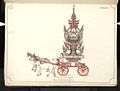 19th-century funeral cart and spire, which would form part of the procession from the home to the place of cremation (from Culture of Myanmar)
 -
 Sculpture of Myanmar mythical lion (from Culture of Myanmar)
 -
 Portuguese ruler and soldiers mounting an elephant. Jan Caspar Philips (draughtsman and engraver). (from History of Myanmar)
 -
 Political map of Burma (Myanmar) c. 1450 CE. (from History of Myanmar)
 -
 Salween river at Mae Sam Laep on the Thai-Myanmar border (from Geography of Myanmar)
 -
 A bull fight, 19th-century watercolour (from Culture of Myanmar)
 -
 Myinhkin thabin - equestrian sport (from Culture of Myanmar)
 -
 Two female musicians play the saung at a performance in Mandalay. (from Culture of Myanmar)
 -
 British invasion of Burma in 1824 (from History of Myanmar)
 -

-
 British soldiers dismantling cannons belonging to King Thibaw's forces, Third Anglo-Burmese War, Ava, 27 November 1885. Photographer: Hooper, Willoughby Wallace (1837–1912). (from History of Myanmar)
 -
 Protesters in Yangon with a banner that reads "non-violence: national movement" in Burmese. In the background is Shwedagon Pagoda. (from History of Myanmar)
 -
 British soldiers on patrol in the ruins of the Burmese town of Bahe during the advance on Mandalay, January 1945 (from History of Myanmar)
 -
 Aung San Suu Kyi addresses crowds at the NLD headquarters shortly after her release. (from History of Myanmar)
 -
 A large fracture on the Mingun Pahtodawgyi caused by the 1839 Ava earthquake. (from Geography of Myanmar)
 -
 A theatrical performance of the Mon dance (from Culture of Myanmar)


![Image 7Military situation in Myanmar as of 2024[update]. Areas controlled by the Tatmadaw are highlighted in red. (from History of Myanmar)](/wiki/File:Myanmar_civil_war.svg?lang=en)


_headquarter.jpg?lang=en)


Major topics
Categories

More topics

Associated Wikimedia
The following Wikimedia Foundation sister projects provide more on this subject:
-
 Commons
Free media repository -
 Wikibooks
Free textbooks and manuals -
 Wikidata
Free knowledge base -
 Wikinews
Free-content news -
 Wikiquote
Collection of quotations -
 Wikisource
Free-content library -
 Wikiversity
Free learning tools -
 Wikivoyage
Free travel guide -
 Wiktionary
Dictionary and thesaurus


