
Portal:World
The World Portal


The world is the totality of entities, the whole of reality, or everything that exists. The nature of the world has been conceptualized differently in different fields. Some conceptions see the world as unique, while others talk of a "plurality of worlds". Some treat the world as one simple object, while others analyze the world as a complex made up of parts.
In scientific cosmology, the world or universe is commonly defined as "the totality of all space and time; all that is, has been, and will be". Theories of modality talk of possible worlds as complete and consistent ways how things could have been. Phenomenology, starting from the horizon of co-given objects present in the periphery of every experience, defines the world as the biggest horizon, or the "horizon of all horizons". In philosophy of mind, the world is contrasted with the mind as that which is represented by the mind.
Theology conceptualizes the world in relation to God, for example, as God's creation, as identical to God, or as the two being interdependent. In religions, there is a tendency to downgrade the material or sensory world in favor of a spiritual world to be sought through religious practice. A comprehensive representation of the world and our place in it, as is found in religions, is known as a worldview. Cosmogony is the field that studies the origin or creation of the world, while eschatology refers to the science or doctrine of the last things or of the end of the world.
In various contexts, the term "world" takes a more restricted meaning associated, for example, with the Earth and all life on it, with humanity as a whole, or with an international or intercontinental scope. In this sense, world history refers to the history of humanity as a whole, and world politics is the discipline of political science studying issues that transcend nations and continents. Other examples include terms such as "world religion", "world language", "world government", "world war", "world population", "world economy", or "world championship". (Full article...)
Selected articles -
-


From Northern Antiquities, an English translation of the Prose Edda from 1847. Painted by Oluf Olufsen Bagge.
The world tree is a motif present in several religions and mythologies, particularly Indo-European, Siberian, and Native American religions. The world tree is represented as a colossal tree which supports the heavens, thereby connecting the heavens, the terrestrial world, and, through its roots, the underworld. It may also be strongly connected to the motif of the tree of life, but it is the source of wisdom of the ages.
Specific world trees include Égig érő fa in Hungarian mythology, Ağaç Ana in Turkic mythology, Kenac' Car in Armenian mythology, Modun in Mongol mythology, Yggdrasil in Norse mythology, Irminsul in Germanic mythology, the oak in Slavic, Finnish and Baltic, Jianmu (Chinese: 建木; pinyin: jiànmù) in Chinese mythology, and in Hindu mythology the Ashvattha (a Ficus religiosa). (Full article...) -
Global change in broad sense refers to planetary-scale changes in the Earth system. It is most commonly used to encompass the variety of changes connected to the rapid increase in human activities which started around mid-20th century, i.e., the Great Acceleration. While the concept stems from research on the climate change, it is used to adopt a more holistic view of the observed changes. Global change refers to the changes of the Earth system, treated in its entirety with interacting physicochemical and biological components as well as the impact human societies have on the components and vice versa. Therefore, the changes are studied through means of Earth system science. (Full article...)
-

Sand dunes in the Rub' al Khali ("Empty quarter") of Arabia
A desert is a landscape where little precipitation occurs and, consequently, living conditions create unique biomes and ecosystems. The lack of vegetation exposes the unprotected surface of the ground to denudation. About one-third of the land surface of the Earth is arid or semi-arid. This includes much of the polar regions, where little precipitation occurs, and which are sometimes called polar deserts or "cold deserts". Deserts can be classified by the amount of precipitation that falls, by the temperature that prevails, by the causes of desertification or by their geographical location.
Deserts are formed by weathering processes as large variations in temperature between day and night strain the rocks, which consequently break in pieces. Although rain seldom occurs in deserts, there are occasional downpours that can result in flash floods. Rain falling on hot rocks can cause them to shatter, and the resulting fragments and rubble strewn over the desert floor are further eroded by the wind. This picks up particles of sand and dust, which can remain airborne for extended periods – sometimes causing the formation of sand storms or dust storms. Wind-blown sand grains striking any solid object in their path can abrade the surface. Rocks are smoothed down, and the wind sorts sand into uniform deposits. The grains end up as level sheets of sand or are piled high in billowing dunes. Other deserts are flat, stony plains where all the fine material has been blown away and the surface consists of a mosaic of smooth stones, often forming desert pavements, and little further erosion occurs. Other desert features include rock outcrops, exposed bedrock and clays once deposited by flowing water. Temporary lakes may form and salt pans may be left when waters evaporate. There may be underground water sources in the form of springs and seepages from aquifers. Where these are found, oases can occur. (Full article...) -

This marker indicating sea level is situated between Jerusalem and the Dead Sea.
Mean sea level (MSL, often shortened to sea level) is an average surface level of one or more among Earth's coastal bodies of water from which heights such as elevation may be measured. The global MSL is a type of vertical datum – a standardised geodetic datum – that is used, for example, as a chart datum in cartography and marine navigation, or, in aviation, as the standard sea level at which atmospheric pressure is measured to calibrate altitude and, consequently, aircraft flight levels. A common and relatively straightforward mean sea-level standard is instead a long-term average of tide gauge readings at a particular reference location.
The term above sea level generally refers to the height above mean sea level (AMSL). The term APSL means above present sea level, comparing sea levels in the past with the level today. (Full article...) -
World government is the concept of a single political authority governing all of Earth and humanity. It is conceived in a variety of forms, from tyrannical to democratic, which reflects its wide array of proponents and detractors.
There has never been a world government with executive, legislative, and judicial functions and an administrative apparatus; the inception of the United Nations (UN) in the mid-20th century remains the closest approximation to a world government, as it is by far the largest and most powerful international institution. The UN is mostly limited to an advisory role, with the stated purpose of fostering cooperation between existing national governments, rather than exerting authority over them. Nevertheless, the organization is commonly viewed as either a model for, or preliminary step towards, a global government. (Full article...) -

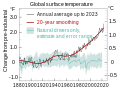
Global average temperatures show that the Medieval Warm Period was not a planet-wide phenomenon, and that the Little Ice Age was not a distinct planet-wide time period but rather the end of a long temperature decline that preceded recent global warming.
The temperature record of the last 2,000 years is reconstructed using data from climate proxy records in conjunction with the modern instrumental temperature record which only covers the last 170 years at a global scale. Large-scale reconstructions covering part or all of the 1st millennium and 2nd millennium have shown that recent temperatures are exceptional: the Intergovernmental Panel on Climate Change Fourth Assessment Report of 2007 concluded that "Average Northern Hemisphere temperatures during the second half of the 20th century were very likely higher than during any other 50-year period in the last 500 years and likely the highest in at least the past 1,300 years." The curve shown in graphs of these reconstructions is widely known as the hockey stick graph because of the sharp increase in temperatures during the last century. As of 2010[update] this broad pattern was supported by more than two dozen reconstructions, using various statistical methods and combinations of proxy records, with variations in how flat the pre-20th-century "shaft" appears. Sparseness of proxy records results in considerable uncertainty for earlier periods.
Individual proxy records, such as tree ring widths and densities used in dendroclimatology, are calibrated against the instrumental record for the period of overlap. Networks of such records are used to reconstruct past temperatures for regions: tree ring proxies have been used to reconstruct Northern Hemisphere extratropical temperatures (within the tropics trees do not form rings) but are confined to land areas and are scarce in the Southern Hemisphere which is largely ocean. Wider coverage is provided by multiproxy reconstructions, incorporating proxies such as lake sediments, ice cores and corals which are found in different regions, and using statistical methods to relate these sparser proxies to the greater numbers of tree ring records. The "Composite Plus Scaling" (CPS) method is widely used for large-scale multiproxy reconstructions of hemispheric or global average temperatures; this is complemented by Climate Field Reconstruction (CFR) methods which show how climate patterns have developed over large spatial areas, making the reconstruction useful for investigating natural variability and long-term oscillations as well as for comparisons with patterns produced by climate models. (Full article...) -
The international community is a term used in geopolitics and international relations to refer to a broad group of people and governments of the world. (Full article...)


General images -
-
 Notre-Dame de Paris, France
 -
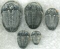 Trilobites first appeared during the Cambrian period and were among the most widespread and diverse groups of Paleozoic organisms. (from History of Earth)
 -
 Obelisk of Axum, Ethiopia
 -
 Benin Bronze head from Nigeria
 -
 European migrations by mostly Germanic peoples, 2nd–6th centuries (from Human history)
 -

-
 A pillar at Neolithic Göbekli Tepe
 -
 Last Moon landing: Apollo 17 (1972)
 -
 Florence, birthplace of the Italian Renaissance
 -
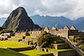 Machu Picchu, Inca Empire, Peru
 -
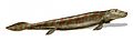 Tiktaalik, a fish with limb-like fins and a predecessor of tetrapods. Reconstruction from fossils about 375 million years old. (from History of Earth)
 -
 Standing Buddha from Gandhara, 2nd century CE
 -
 Satellite time lapse imagery of Earth's rotation showing axis tilt (from Earth)
 -
-
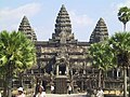 Angkor Wat temple complex, Cambodia, early 12th century
 -
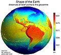 Earth's western hemisphere showing topography relative to Earth's center instead of to mean sea level, as in common topographic maps (from Earth)
 -
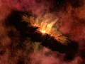
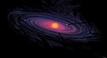 An artist's rendering of a protoplanetary disk (from History of Earth)
 -

-

-
 Fall of the Berlin Wall, 1989
 -
 Olmec colossal head, now at the Museo de Antropología de Xalapa
 -
 A map of heat flow from Earth's interior to the surface of Earth's crust, mostly along the oceanic ridges (from Earth)
 -
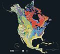 Geologic map of North America, color-coded by age. From most recent to oldest, age is indicated by yellow, green, blue, and red. The reds and pinks indicate rock from the Archean.
 -
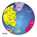 A reconstruction of Pannotia (550 Ma). (from History of Earth)
 -
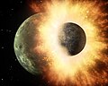 Artist's impression of the enormous collision that probably formed the Moon (from History of Earth)
 -
-
 A 2012 artistic impression of the early Solar System's protoplanetary disk from which Earth and other Solar System bodies were formed (from Earth)
 -
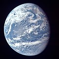 A view of Earth with its global ocean and cloud cover, which dominate Earth's surface and hydrosphere; at Earth's polar regions, its hydrosphere forms larger areas of ice cover. (from Earth)
 -
 Chloroplasts in the cells of a moss (from History of Earth)
 -
 A composite image of artificial light emissions at night on a map of Earth (from Earth)
 -
 Graph showing range of estimated partial pressure of atmospheric oxygen through geologic time (from History of Earth)
 -
 The replicator in virtually all known life is deoxyribonucleic acid. DNA is far more complex than the original replicator and its replication systems are highly elaborate. (from History of Earth)
 -
 Japanese depiction of a Portuguese carrack, a result of globalizing maritime trade
 -
 An artist's impression of the Archean, the eon after Earth's formation, featuring round stromatolites, which are early oxygen-producing forms of life from billions of years ago. After the Late Heavy Bombardment, Earth's crust had cooled, its water-rich barren surface is marked by continents and volcanoes, with the Moon still orbiting Earth half as far as it is today, appearing 2.8 times larger and producing strong tides. (from Earth)
 -
 Pangaea was a supercontinent that existed from about 300 to 180 Ma. The outlines of the modern continents and other landmasses are indicated on this map. (from History of Earth)
 -
 Earth's land use for human agriculture in 2019 (from Earth)
 -
 Chennakesava Temple, Belur, India
 -
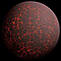 Artist's conception of Hadean Eon Earth, when it was much hotter and inhospitable to all forms of life. (from History of Earth)
 -
 Portrait of Alfraganus in the Compilatio astronomica, 1493. Islamic astronomers began just before the 9th century to collect and translate Indian, Persian and Greek astronomical texts, adding their own astronomy and enabling later, particularly European astronomy to build on. Symbolic for the post-classical period, a period of an increasing trans-regional literary culture, particularly in the sciences, spreading and building on methods of science. (from Human history)
 -
 Change in average surface air temperature and drivers for that change. Human activity has caused increased temperatures, with natural forces adding some variability. (from Earth)
 -
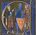 13th-century French historiated initial with the three classes of medieval society: those who prayed (the clergy), those who fought (the knights), and those who worked (the peasantry)
 -
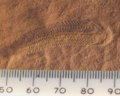 A 580 million year old fossil of Spriggina floundensi, an animal from the Ediacaran period. Such life forms could have been ancestors to the many new forms that originated in the Cambrian Explosion. (from History of Earth)
 -
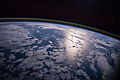
 Tracy Caldwell Dyson, a NASA astronaut, observing Earth from the Cupola module at the International Space Station on 11 September 2010 (from Earth)
 -
 One of the eleven Rock-hewn Churches of Lalibela constructed during the Zagwe dynasty in Ethiopia (from Human history)
 -
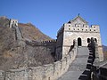 Ming dynasty section, Great Wall of China
 -
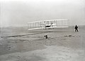 The first airplane, the Wright Flyer, flew on 17 December 1903.
 -
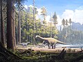 Dinosaurs were the dominant terrestrial vertebrates throughout most of the Mesozoic (from History of Earth)
 -
 An animation of the changing density of productive vegetation on land (low in brown; heavy in dark green) and phytoplankton at the ocean surface (low in purple; high in yellow) (from Earth)
 -
 An artist's impression of ice age Earth at glacial maximum. (from History of Earth)
 -
 A reconstruction of human history based on fossil data. (from History of Earth)
 -
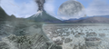
 Artist's impression of a Hadean landscape with the relatively newly formed Moon still looming closely over Earth and both bodies sustaining strong volcanism. (from History of Earth)
 -
 Cross-section through a liposome (from History of Earth)
 -
 Artist's conception of Devonian flora (from History of Earth)
 -
 Empires of the world in 1898
 -
 Cuneiform inscription, eastern Turkey
 -
 Pale orange dot, an artist's impression of Early Earth, featuring its tinted orange methane-rich early atmosphere (from Earth)
 -
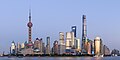 Shanghai. China urbanized rapidly in the 21st century.
 -
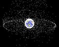 A computer-generated image mapping the prevalence of artificial satellites and space debris around Earth in geosynchronous and low Earth orbit (from Earth)
 -
 Yggdrasil, an attempt to reconstruct the Norse world tree which connects the heavens, the world, and the underworld. (from World)
 -
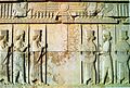 Carving of Persian and Median soldiers, Persepolis, Achaemenid Empire, 5th century BCE
 -
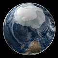 A composite image of Earth, with its different types of surface discernible: Earth's surface dominating Ocean (blue), Africa with lush (green) to dry (brown) land and Earth's polar ice in the form of Antarctic sea ice (grey) covering the Antarctic or Southern Ocean and the Antarctic ice sheet (white) covering Antarctica. (from Earth)
 -
 Battle during the 1281 Mongol invasion of Japan
 -

-
 A view of Earth with different layers of its atmosphere visible: the troposphere with its clouds casting shadows, a band of stratospheric blue sky at the horizon, and a line of green airglow of the lower thermosphere around an altitude of 100 km, at the edge of space (from Earth)
 -

-
-
-

-
 COVID-19 pandemic, 2020 (from Human history)
 -
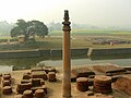 Pillar erected by Ashoka, a Mauryan Emperor in India
 -
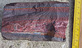 A banded iron formation from the 3.15 Ga Moodies Group, Barberton Greenstone Belt, South Africa. Red layers represent the times when oxygen was available; gray layers were formed in anoxic circumstances. (from History of Earth)
 -
 Earth's night-side upper atmosphere appearing from the bottom as bands of afterglow illuminating the troposphere in orange with silhouettes of clouds, and the stratosphere in white and blue. Next the mesosphere (pink area) extends to the orange and faintly green line of the lowest airglow, at about one hundred kilometers at the edge of space and the lower edge of the thermosphere (invisible). Continuing with green and red bands of aurorae stretching over several hundred kilometers. (from Earth)
 -

-

-
The pale orange dot, an artist's impression of the early Earth which might have appeared orange through its hazy methane rich prebiotic second atmosphere. Earth's atmosphere at this stage was somewhat comparable to today's atmosphere of Titan. (from History of Earth)
-
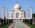 Taj Mahal, Mughal Empire, India
 -
 A schematic view of Earth's magnetosphere with solar wind flowing from left to right (from Earth)
 -
 Artist's rendition of an oxinated fully-frozen Snowball Earth with no remaining liquid surface water. (from History of Earth)
 -
 Successive dispersals of Homo erectus (yellow), Homo neanderthalensis (ochre) during Out of Africa I and Homo sapiens (red, Out of Africa II), with the numbers of years since they appeared before present. (from Human history)
 -
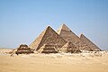 Great Pyramids of Giza, Egypt
 -
 Earth's axial tilt causing different angles of seasonal illumination at different orbital positions around the Sun (from Earth)
 -
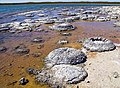 Lithified stromatolites on the shores of Lake Thetis, Western Australia. Archean stromatolites are the first direct fossil traces of life on Earth. (from History of Earth)
 -
 Vitruvian Man by Leonardo da Vinci epitomizes the advances in art and science seen during the Renaissance. (from History of Earth)
 -
Artist's impression of Earth during the later Archean, the largely cooled planetary crust and water-rich barren surface, marked by volcanoes and continents, features already round microbialites. The Moon, still orbiting Earth much closer than today and still dominating Earth's sky, produced strong tides. (from History of Earth)
-
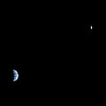
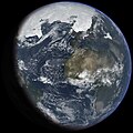
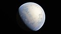
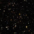 Image of the physical world, captured by the Hubble Space Telescope (from World)
 -

-
 Earth's history with time-spans of the eons to scale. Ma means "million years ago". (from History of Earth)


.jpeg?lang=en)

.svg?lang=en)


.jpg?lang=en)


.png?lang=en)


.jpg?lang=en)


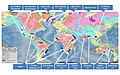
Megacities of the world -

Kinshasa (/kɪnˈʃɑːsə/; French: [kinʃasa]; Lingala: Kinsásá), formerly named Léopoldville from 1881–1966 (Dutch: Leopoldstad), is the capital and largest city of the Democratic Republic of the Congo. Kinshasa is one of the world's fastest-growing megacities, with an estimated population of 17.8 million in 2024. It is the most densely populated city in the DRC, the second-most populous city and third-largest metropolitan area in Africa, and the world's twenty-second most populous city and fourth-most populous capital city. It is the leading economic, political, and cultural center of the DRC, housing several industries including manufacturing, telecommunications, banking, and entertainment. The city also hosts some of DRC's significant institutional buildings, such as the People's Palace, Palace of the Nation, Court of Cassation, Constitutional Court, African Union City, Marble Palace, Martyrs Stadium, Government House, Kinshasa Financial Center, and other national departments and agencies.
The Kinshasa site has been inhabited by Teke and Humbu people for centuries and was known as Nshasa before transforming into a commercial hub during the 19th and 20th centuries. The city was named Léopoldville by Henry Morton Stanley in honor of Leopold II of Belgium. The name was changed to Kinshasa in 1966 during Mobutu Sese Seko's Zairianisation campaign as a tribute to Nshasa village. Covering 9,965 square kilometers, Kinshasa stretches along the southern shores of the Pool Malebo on the Congo River. It forms an expansive crescent across flat, low-lying terrain at an average altitude of about 300 meters. Kinshasa borders the Mai-Ndombe Province, Kwilu Province, and Kwango Province to the east; the Congo River delineates its western and northern perimeters, constituting a natural border with the Republic of the Congo; to the south lies the Kongo Central Province. Across the river sits Brazzaville, the smaller capital of the neighboring Republic of the Congo, forming the world's closest pair of capital cities despite being separated by a four-kilometer-wide unbridged span of the Congo River. (Full article...)
Did you know -

- ... that Ertuğrul Gazi, a Turkish floating storage and regasification unit for liquefied natural gas, has a daily capacity of 28 million cubic metres (990 million cu ft), among the world's largest?
- ... that ratline organizer Ivo Omrčanin once beat a suspected informant with an umbrella?
- ... that St. Bernward in Döhren was consecrated in 1893, when part of Christoph Hehl's design of a basilica in the Romanesque Revival style was built, but the building was only completed after World War II?
- ... that Patrick Gottsch, the founder of RFD-TV and The Cowboy Channel, led the effort to break the Guinness World Record for the largest parade of pickup trucks?
- ... that Hungarians Gyula Bajó and Endre Hevizi, who went on to design stained glass for the Debre Libanos monastery, worked as labourers in a British pottery after the Second World War?
- ... that goalkeeper Daniela Solera had the most touches of any Costa Rican player in their opening match of the 2023 World Cup?
- ... that after being freed from Buq Buq labor camp in Italian-occupied Egypt, Libyan Jewish prisoners had to walk home across the desert?
- ... that the then–prime minister of New Zealand said that the greatest impact of the December 2011 Christchurch earthquakes was on mental health?
Countries of the world -

Paraguay, officially the Republic of Paraguay, is a landlocked American country located in the central region of South America. It is a unitary state with a territory composed of a capital district and seventeen provinces. Its capital and largest city is Asunción. Paraguay is a presidential republic and a state governed by the rule of law. It is a founding member of Mercosur, along with Argentina, Brazil and Uruguay.
Spanish conquistadores arrived in 1524, and in 1537 established the city of Asunción, the first capital of the Governorate of the Río de la Plata. During the 17th century, Paraguay was the center of Jesuit missions, where the native Guaraní people were converted to Christianity and introduced to European culture. After the expulsion of the Jesuits from Spanish territories in 1767, Paraguay increasingly became a peripheral colony. Following independence from Spain in the early 19th century, Paraguay was ruled by a series of authoritarian governments. This period ended with the disastrous Paraguayan War (1864–1870), during which the country lost half its prewar population and around 25–33% of its territory. In the 20th century, Paraguay faced another major international conflict—the Chaco War (1932–1935) against Bolivia—in which Paraguay prevailed. The country came under a succession of military dictators, culminating in the 35-year regime of Alfredo Stroessner, which lasted until his overthrow in 1989 by an internal military coup. This marked the beginning of Paraguay's current democratic era. (Full article...)

The Seven Wonders of Wales (Welsh: Saith Rhyfeddod Cymru) is a traditional list of notable landmarks in north Wales, commemorated in an anonymously written rhyme:
The rhyme is usually supposed to have been written sometime in the late 18th or early 19th century by an English visitor to North Wales. The specific number of wonders may have varied over the years: the antiquary Daines Barrington, in a letter written in 1770, refers to Llangollen Bridge as one of the "five wonders of Wales, though like the seven wonders of Dauphiny, they turn out to be no wonders at all out of the Principality". (Full article...)
Related portals
Protected areas of the world -
-

Tijuca Forest National Park
Protected areas of Brazil included various classes of area according to the National System of Nature Conservation Units (SNUC), a formal, unified system for federal, state and municipal parks created in 2000. (Full article...) -
As of present, there are around 400 protected areas in Pakistan that are recognized by International Union for Conservation of Nature (IUCN). The total protected land area represents 13% of Pakistan's landmass as of 2020, The Government of Pakistan plans to increase it to at least 15% by 2023. As a signatory of the UN Convention on Biological Diversity, Pakistan is committed to expanding its protected areas to encompass 17% of its total territory by the year 2030. This ambitious goal aims to ensure the long-term conservation of nature, safeguard vital ecosystem services, and preserve the cultural values associated with these protected areas. (Full article...)
-
Protected areas of Tamil Nadu cover an area of 3,305 km2 (1,276 sq mi), constituting 2.54% of the geographic area and 15% of the 22,643 km2 (8,743 sq mi) recorded forest area of the state of Tamil Nadu in South India. It ranks 14th among all the states and union territories of India in terms of total protected area.
Protected areas in South India were created from private hunting grounds of the erstwhile Maharajas of the princely states. Mudumalai National Park was established in 1940 and was the first modern wildlife sanctuary in South India. The protected areas are administered by the Ministry of Environment and Forests of Government of India and the Tamil Nadu Forest Department. (Full article...) -
The protected areas of South Africa include national parks and marine protected areas managed by the national government, public nature reserves managed by provincial and local governments, and private nature reserves managed by private landowners. Most protected areas are intended for the conservation of flora and fauna. National parks are maintained by South African National Parks (SANParks). A number of national parks have been incorporated in transfrontier conservation areas.
Protected areas may also be protected for their value and importance as historical, cultural heritage or scientific sites. More information on these can be found in the list of heritage sites in South Africa. (Full article...) -
Protected areas of Sri Lanka are administrated by Department of Forest Conservation and Department of Wildlife Conservation of Sri Lanka.There are 501 protected areas in Sri Lanka. The protected areas that fall under supervision of the Department of Forest Conservation include forests defined in National Heritage Wilderness Area Act in 1988, forest reservations, and forests managed for sustainability. Sinharaja Forest Reserve is an example for a National Heritage forest (it is also a World Heritage Site). There are 32 forests categorized as conservation forests including Knuckles Mountain Range. Strict nature reserves, national parks, nature reserves, forest corridors, and sanctuaries recognized under the Flora and Fauna Protection Ordinance are managed by Department of Wildlife Conservation. Total of all protected areas is 1,767,000 ha. Protected areas in Sri Lanka account for 26.5 percent of the total area. This is a higher percentage of protected areas than in all of Asia and much of the World. (Full article...)
-
A National Biodiversity Conservation Area (NBCA) is an environmentally protected area in Laos. There are altogether 21 different NBCAs in Laos, protecting 29,775 square kilometers. Another 10 NBCAs have been proposed, the territory of many of them being treated by authorities as though they were already officially protected. (Full article...)
-

The mountain of Stob Binnein lies in the Loch Lomond and The Trossachs National Park.
Many parts of Scotland are protected in accordance with a number of national and international designations because of their environmental, historical or cultural value. Protected areas can be divided according to the type of resource which each seeks to protect. NatureScot has various roles in the delivery of many environmental designations in Scotland, i.e. those aimed at protecting flora and fauna, scenic qualities and geological features. Historic Environment Scotland is responsible for designations that protect sites of historic and cultural importance. Some international designations, such as World Heritage Sites, can cover both categories of site.
The various designations overlap considerably with many protected areas being covered by multiple designations with different boundaries. (Full article...) -

Centre for Nature Education at the Białowieża National Park, Poland
Protected areas of Poland include the following categories, as defined by the Act on Protection of Nature (Polish: Ustawa o ochronie przyrody) of 16 April 2004, by the Polish Parliament: (Full article...) -
This is a list of protected areas of Saudi Arabia, some of which are managed by the Saudi Wildlife Authority.:
- At-Taysiyah Protected Area
- Jabal Shada Nature Reserve
- Majami'al-Hadb Protected Area
- Nafud al-'Urayq
- Raydah Natural Reserve
- 'Uruq Bani Ma'arid
- Saja Umm Ar-Rimth Natural Reserve
- Harrat al-Harrah Protected Area
- Al-Khunfah Natural Reserve
- Ibex Reserve Protected Area
- Mahazat as-Sayd Protected Area
- Umm al-Qamari Islands
- Al-Tubayq Natural Reserve
- Farasan Islands Protected Area
- Jubail Marine Wildlife Sanctuary
- Jabal Aja Protected Area
- Wadi Turabah Nature Reserve
-
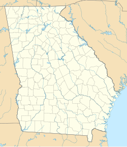
Map of Georgia
The protected areas of Georgia cover almost one million acres (4,000 km2) of the state. These areas are managed by different federal and state level authorities and receive varying levels of protection. Some areas are managed as wilderness while others are operated with acceptable commercial exploitation. On the Federal level, Georgia contains 1 Biosphere Reserve, 15 National Park Service Managed Sites, 1 National Forest and 8 Wildlife Refuges. Georgia is home to 63 state parks, 48 of which are state parks and 15 that are National Historic Sites, and many state wildlife preserves, under the supervision of the Georgia Department of Parks and Recreation, a division of the Georgia Department of Natural Resources. (Full article...) -

Heathland at the Hoge Kempen National Park
There are numerous protected areas in Belgium with a wide variety of types, protection levels and sizes. The below list gives an overview of the most important protected areas. (Full article...) -
The protected areas of Nepal cover mainly forested land and are located at various altitudes in the Terai, in the foothills of the Himalayas and in the mountains, thus encompassing a multitude of landscapes and preserving a vast biodiversity in the Palearctic and Indomalayan realms.
Nepal covers 147,181 km2 (56,827 sq mi) in the central part of the Himalayas. Altitudes range from 67 m (220 ft) in the south-eastern Terai to 8,848 m (29,029 ft) at Mount Everest within a short horizontal span. This extreme altitudinal gradient has resulted in 11 bio-climatic zones ranging from lower tropical below 500 m (1,600 ft) to nival above 5,000 m (16,000 ft) in the High Himalayas, encompassing nine terrestrial ecoregions with 36 vegetation types.
Additionally, nine Ramsar sites were declared between 1988 and 2008. Two wildlife reserves were declared as national parks in 2017. (Full article...) -
Protected areas of Indonesia comprise both terrestrial and marine environments in any of the six IUCN Protected Area categories. There are over 500 protected areas in Indonesia, of which 57 National Parks and another nature and game reserves cover overall 36.1 million ha land area. The total protected land area represents over 18.9% of Indonesia's landmass.Marine Protected Areas comprise over 28.4 million ha (around 9% of Indonesian territorial waters). (Full article...)
-
The National Parks of Argentina make up a network of 35 national parks in Argentina. The parks cover a very varied set of terrains and biotopes, from Baritú National Park on the northern border with Bolivia to Tierra del Fuego National Park in the far south of the continent. The Administración de Parques Nacionales (National Parks Administration) is the agency that preserves and manages these national parks along with Natural monuments and National Reserves within the country.
The headquarters of the National Parks Service are in downtown Buenos Aires, on Santa Fe Avenue. A library and information centre are open to the public. The administration also covers the national monuments, such as the Jaramillo Petrified Forest, and natural and educational reserves. (Full article...) -
This is a list of protected areas in Bulgaria which includes 3 national parks, 11 nature parks and 55 nature reserves. The national policy for governing and management of the protected areas is implemented by the Ministry of Environment and Water. The first nature park in Bulgaria and the Balkan Peninsula is Vitosha Nature Park, established in 1934. All of the nationally protected areas in Bulgaria are also part of the Natura 2000 network of protected natural areas in the territory of the European Union. Bulgaria has some of the largest Natura 2000 areas in the European Union covering 33.8% of its territory.
- Parks and reserves in italic letters are part of Global 200 ecoregions.


Selected world maps
-
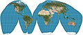 The Goode homolosine projection is a pseudocylindrical, equal-area, composite map projection used for world maps.
 -
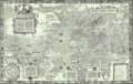
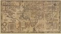 1516 map of the world by Martin Waldseemüller
 -
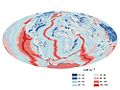
 Only a few of the largest large igneous provinces appear (coloured dark purple) on this geological map, which depicts crustal geologic provinces as seen in seismic refraction data
 -
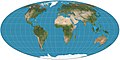 Mollweide projection of the world
 -
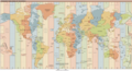 Time zones of the world
 -
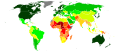 United Nations Human Development Index map by country (2016)
 -
 The world map by Gerardus Mercator (1569), the first map in the well-known Mercator projection
 -
 Index map from the International Map of the World (1:1,000,000 scale)
 -
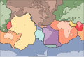
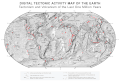 A plate tectonics map with volcano locations indicated with red circles


World records
- List of Olympic records in athletics
- List of world records in athletics
- List of junior world records in athletics
- List of world records in masters athletics
- List of world youth bests in athletics
- List of IPC world records in athletics
- List of world records in canoeing
- List of world records in chess
- List of cycling records
- List of world records in track cycling
- List of world records in finswimming
- List of world records in juggling
- List of world records in rowing
- List of world records in speed skating
- List of world records in swimming
- List of IPC world records in swimming
- List of world records in Olympic weightlifting
Topics

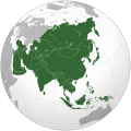
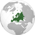
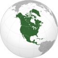
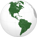
Continents of Earth | ||||||||
|---|---|---|---|---|---|---|---|---|
| ||||||||
| ||||||||
| ||||||||


| Cenozoic Era (present–66.0 Ma) |
| ||||||||||||
|---|---|---|---|---|---|---|---|---|---|---|---|---|---|
| Mesozoic Era (66.0–252 Ma) |
| ||||||||||||
| Paleozoic Era (252–539 Ma) |
| ||||||||||||
| Proterozoic Eon (539 Ma–2.5 Ga) |
| ||||||||||||
| Archean Eon (2.5–4 Ga) | |||||||||||||
| Hadean Eon (4–4.6 Ga) | |||||||||||||
ka = kiloannum (thousand years ago); Ma = megaannum (million years ago); Ga = gigaannum (billion years ago). See also: Geologic time scale • | |||||||||||||
| Locations | ||
|---|---|---|
| Related | ||

| |||||||||||||||||||
| |||||||||||||||||||
| |||||||||||||||||||
Economic classification of countries | |||||
|---|---|---|---|---|---|
| Three-World Model | |||||
| Gross domestic product (GDP) |
| ||||
| Gross national income (GNI) | |||||
| Wages | |||||
| Wealth | |||||
| Other national accounts | |||||
| Human development | |||||
| Digital divide | |||||
| Net international investment position (NIIP) | |||||
| Technological |
| ||||
|---|---|---|---|---|---|
| Sociological | |||||
| Ecological |
| ||||
| Biological |
| ||||
| Astronomical | |||||
| Eschatological |
| ||||
| Others |
| ||||
| Fictional | |||||
| Organizations | |||||
Categories

Wikimedia
The following Wikimedia Foundation sister projects provide more on this subject:
-
 Commons
Free media repository -
 Wikibooks
Free textbooks and manuals -
 Wikidata
Free knowledge base -
 Wikinews
Free-content news -
 Wikiquote
Collection of quotations -
 Wikisource
Free-content library -
 Wikispecies
Directory of species -
 Wikiversity
Free learning tools -
 Wikivoyage
Free travel guide -
 Wiktionary
Dictionary and thesaurus


